
By Madeleine Gregory
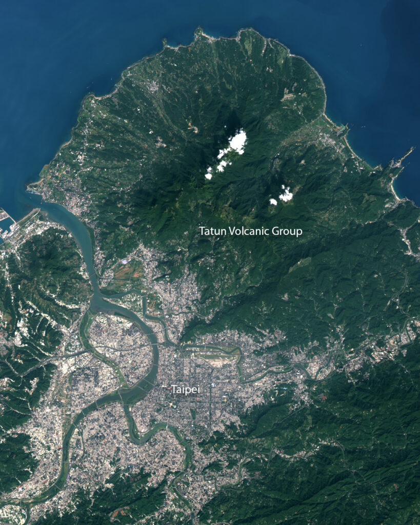
On a clear day in Taipei, Taiwan, layers of scraggly mountain skylines recede into hazier and hazier blues. Taipei is nestled in the Taipei Basin, an almost-triangular flat region hedged in by mountains on every side. To the north is Yangmingshan National Park: home to the Tatun Volcanic Group.
These volcanoes aren’t known to erupt, but their shifting stores of magma do influence the high levels of seismic activity in the region. Research published in November 2023 in Scientific Reports explored this connection in a novel way, using over 30 years of Landsat-derived land surface temperature and seismic records to find a positive correlation between land surface temperature and earthquake magnitude.
The researchers began by analyzing trends in land surface temperature (LST) from Landsat data collected from 1984 to 2022, focusing on “thermal anomalies”—areas where the temperature was high relative to the surrounding area. These surface temperatures are influenced by the temperatures below the ground, identifying areas of higher magma activity. The team isolated four thermal hotspots for further investigation, then chose an area called Dayoukeng—which had the highest consistent thermal anomaly—for further analysis.
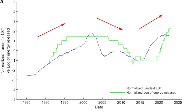
Next, they analyzed earthquake records from Taiwan’s Central Weather Bureau Seismographic Network, selecting all earthquakes centered at Dayoukeng with a diameter of 20 km, a depth of less than 30 km, and a magnitude higher than 1.5. They calculated the energy released from these quakes daily and charted it from 1991 to 2022.
The researchers compared the trends in land surface temperature and earthquake magnitude and found a clear correlation. When land surface temperature increased, so did energy released in earthquakes; when it decreased, earthquake energy also declined.
This research is preliminary, but has the potential to influence hazard management in the region. Living in a fault zone, the seven million residents of Taipei expect frequent earthquakes, typically seeing 3 or 4 with magnitude of 6 or greater each year. (For reference, the entire state of California—over 11 times the size of Taiwan—sees two to three earthquakes magnitude 5.5 or greater each year.) Earthquakes are notoriously difficult to predict; people often get alerts mere seconds before a quake hits. LST could be included in future monitoring efforts, potentially aiding researchers in giving the residents of Taipei more warning before the ground begins to shake.
The research is part of a larger effort to understand the Tatun Volcano Group more intricately. For a long time, the volcanoes were considered dormant. The last major volcanic activity was pegged to 200,000 years ago by radiometric dating of volcanic rock. However, research examining volcanic ash revealed much more recent activity: the last eruption was likely 6,000 years ago. A separate study unveiled another key aspect of volcanic activity: the Tatun magma reservoir, which is much shallower than previously thought.
In studying the Tatun Volcano Group, researchers are trying to see below the Earth’s surface. Without the luxury of direct observation, researchers in Chan et al. relied on two key features of Landsat: its thermal data and the longevity of its mission. Landsat now looks to strengthen its legacy: Landsat Next, set to launch in 2031, will provide three new thermal bands alongside improved temporal and spatial resolution. This long-term, ever-improving data—combined with more sophisticated on-the-ground seismic monitoring—may help unravel the mysteries of magma and movement beneath our feet.
Reference
Chan, H.; Chan, Y.; Sun, C. Thermal Pattern of Tatun Volcanic System by Satellite-Observed Temperatures and Its Correlation with Earthquake Magnitudes. Scientific Reports 2023, 13, 19568. https://doi.org/10.1038/s41598-023-47048-1


