Landsat 9 Passes Key Decision Point C, Moves on to Implementation Phase

Landsat 9 Passes Key Decision Point C, Moves on to Implementation Phase

As of Dec. 6, 2017, Landsat 9 has entered its implementation phase, or “Phase C” of its project lifecycle after successfully passing Key Decision Point C (KDP-C). The Landsat 9 project team garnered high praise from NASA Headquarters’ Agency Program Management Council (or APMC) for the project’s exemplary mission formulation performance and for the lockstep collaboration with its partner agency, the U.S. Geologic Survey.
“It is rare for a project to come to the APMC with such a successful story and incredibly clean status for KDP-C,” said Del Jenstrom, the Landsat 9 Project Manager. “The stellar progress being made on all elements of the project by our combined government and contractor team was clearly on display.”
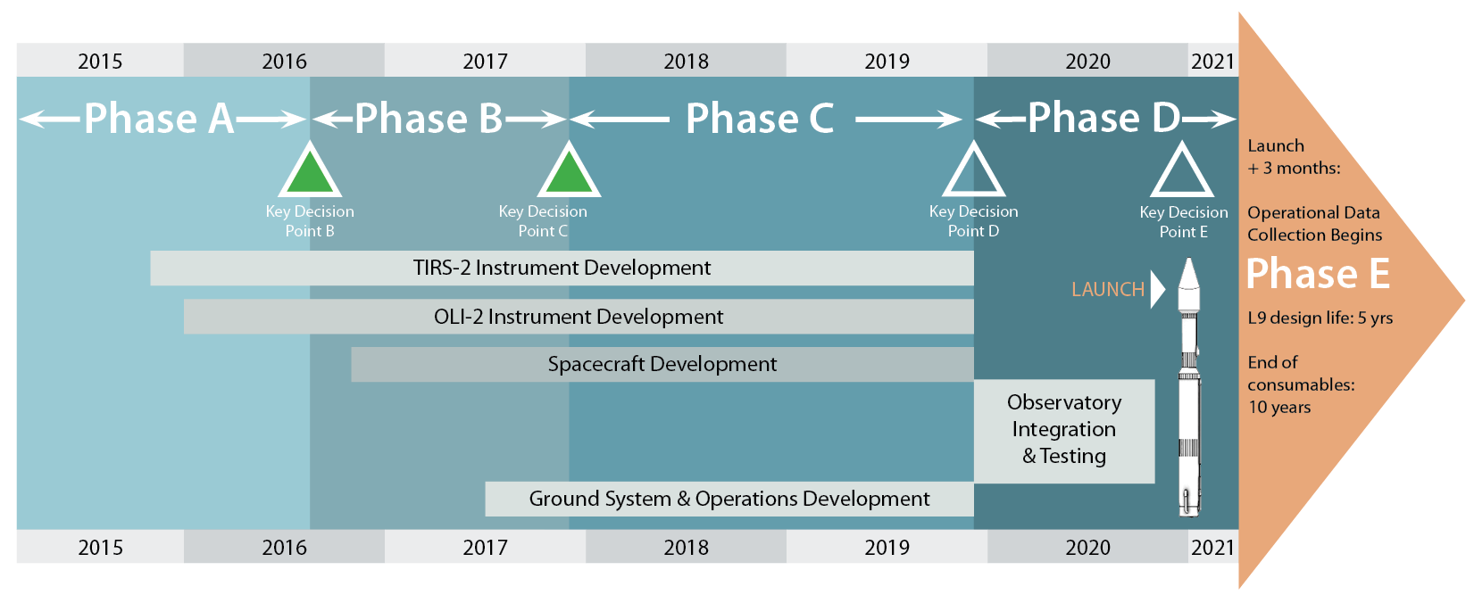
The implementation phase of the Landsat 9 project lifecycle will be dominated by the fabrication and testing of the Landsat 9 instruments and spacecraft; this phase will last approximately 24 months and will be followed by the observatory integration phase.
Landsat 9 remains on track for its aggressive December 2020 launch date.

Landsat 9 project lifecycle
A timeline of Landsat 9 mission development and lifecycle. (The launch vehicle for Landsat 9 will be a ULA Atlas V 401.)

Get the latest from Landsat in your inbox.


By submitting this form, you are consenting to receive marketing emails from: Landsat Science. You can revoke your consent to receive emails at any time by using the SafeUnsubscribe® link, found at the bottom of every email. Emails are serviced by Constant Contact
On Key

Recent Posts

Map shows South Korea with waterways highlighted. In the top right corner is a north arrow and in the bottom left corner is a legend of different rivers in South Korea.

Monitoring Water Quality in South Korea

South Korea is facing a water quality problem. Researchers Hyunglok Kim and Seongjun Lee from the Gwangju Institute of Science and Technology (GIST) embarked on developing a model to predict water quality indicators in near real-time.

Read More »
Landsat outreach specialist Allison Nussbaum and GEDI/UMD Faculty Specialist Talia Schwelling hold Landsat/GEDI postcards at the NASA exhibit booth at AGU24.

Landsat at AGU24

The NASA Landsat Science and Outreach teams attended the American Geophysical Union’s annual meeting in DC in December. At AGU24, they shared research and educated the public about Landsat.

Read More »
On Key

Related Posts

Map shows South Korea with waterways highlighted. In the top right corner is a north arrow and in the bottom left corner is a legend of different rivers in South Korea.

Monitoring Water Quality in South Korea

South Korea is facing a water quality problem. Researchers Hyunglok Kim and Seongjun Lee from the Gwangju Institute of Science and Technology (GIST) embarked on developing a model to predict water quality indicators in near real-time.

Read More »
Landsat outreach specialist Allison Nussbaum and GEDI/UMD Faculty Specialist Talia Schwelling hold Landsat/GEDI postcards at the NASA exhibit booth at AGU24.

Landsat at AGU24

The NASA Landsat Science and Outreach teams attended the American Geophysical Union’s annual meeting in DC in December. At AGU24, they shared research and educated the public about Landsat.

Read More »