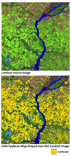
It turns out that GDA is the second largest commercial downloader of Landsat imagery from the USGS worldwide. Not bad for a small business that formed in 2004 from a NASA Small Business Innovation Research (SBIR) project on developing a fully automated procedure for identifying clouds and their shadows in Landsat-class imagery (http://www.gdacorp.com/casa/). From that one project, GDA has branched out to develop a handful of image processing techniques for a range of commercial and government satellites and serves a multitude of clients across the globe. Landsat, however, is the sensor that GDA turns to repeatedly to solve client problems, either at client request or by suggestion from GDA. Dr. Hulina notes, “Landsat imagery is the workhorse sensor at GDA. Its 30 meter resolution, large number of multispectral bands which include NIR and MIR data, its long historical record, along with excellent sensor calibration provides the absolute best bang for the buck compared to all other sensors currently out there for fine level monitoring of local and global land cover and land cover change.”
GDA client interests range from detection of data gaps in the imagery, image calibration to surface reflectance, and image mosaicking to full-blown image analysis to answer questions like when, where, and how much of a particular crop is planted in a particular region for any given year. Landsat imagery is exceptionally well suited for agricultural analysis up to the field level. GDA is especially proud of their long-standing working relationship with the Foreign Agricultural Service (FAS) of the USDA. Working with the Office of Global Analysis/International Production Assessment Division within FAS, GDA has used its technology alongside the expertise of the USDA/FAS to provide timely and accurate global crop intelligence while consistently covering all major agricultural regions annually. GDA analysis of Landsat imagery and the final products generated from it factor into the global production forecasts that FAS releases every month. The national importance of FAS activities is evidenced by the inclusion of its “World Agricultural Supply and Demand Estimates and World Agricultural Production (WASDE)” USDA publication in the Office of Management and Budget’s (OMB) Principal Federal Economic Indicators for the White House.
“The impact of free access to the USGS Landsat imagery on businesses and business opportunities is hard to overestimate,” Dr. Hulina notes. “It can be compared to the business opportunities enabled by free access to Google Earth.” A significant part of GDA daily business relies on processing and analysis of Landsat imagery and rapid delivery of value-added products to clients. This would not be possible without free, reliable, and high quality Landsat data offered by USGS.
“We have developed an end to end processing system around Landsat for our clients. We monitor the USGS EROS archives for new imagery additions and continually collect new images of interest for our clients across the globe. Within seconds of download, these Landsat images are going through our processing system, and we are delivering end-products to clients in hours to several days after ingest depending on the scale of the project.
“We have big plans to continue to push our use of Landsat in new directions and build upon our processing system for existing and new clients. We are very much looking forward to the launch of Landsat 8 and beyond. With this data availability, we see a bright future for GDA and the many clients we serve.”
Source: USGS Landsat Stories
Original article:
+ USGS Landsat Stories: Landsat Adds Tremendous Value to Decision-Making and Bottom Line

A Rendezvous with Landsat
NASA outreach specialists led educators through a workshop on accessing and utilizing Landsat data at the annual Earth Educators’ Rendezvous.


