Search
Close this search box.

Landsat at Explore@Goddard

Landsat at Explore@Goddard

visitors look at Landsat image cubes
Visitors inspect Landsat image cubes showing land use change over time; Terry Arvidson points out features. Photo credits: Jeannie Allen

kids looking at Chesapeake Bay mosaic
Children exploring the large Landsat Chesapeake Bay mosaic while Landsat 8 Project Scientist, Jim Irons, shares information with their mom. Photo credit: Mike Taylor
On Saturday, September 26, over 20,000 people attended an all-day public open house at NASA’s Goddard Space Flight Center in Greenbelt, Maryland. The “Explore@Goddard” event shared with the public some of the science and technology that is developed and used on the Goddard campus everyday. Talks and exhibits entertained, educated, and engaged visitors of all ages.
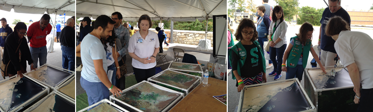
The Landsat exhibit booth shared how Landsat helps us to understand our changing lands. The Landsat Communications and Public Engagement staff together with with Sr. Systems Engineer Theresa Arvidson (Lockheed Martin) and Sally Cook (USGS) helped visitors explore Landsat mosaics of the Chesapeake Bay watershed and large cubes that featured images of the same places during different decades. The crowd of visitors included many family groups.
Further Reading:
+ Explore@NASAGoddard Attracts Record Crowd of 20,000
Explore@Goddard visitors exploring at the Landsat booth. Photo credit: Jeannie Allen.

On Key

Recent Posts

Earthrise

Remembering Bill Anders

Anders, 90, the astronaut who captured the iconic Earthrise photograph, died on June 7, 2024, when the plane he was piloting crashed into the San Juan Channel.

Read More »
On Key

Related Posts