
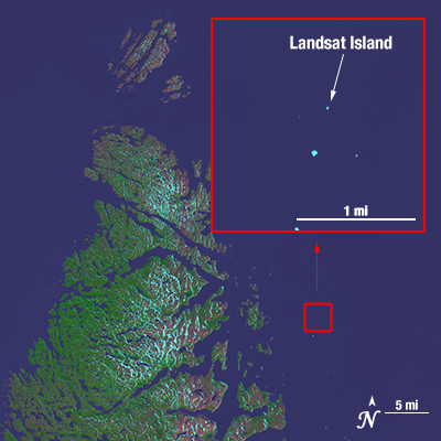
Off the northeastern coast of Labrador, in the northern most reaches of the Newfoundland & Labrador province lies Landsat Island, an icy isle inhabited only by polar bears. How did such a place get named after a satellite?
In 1976, Landsat data were used as part of a Canadian coastal survey. The Landsat images revealed a number of uncharted features; the largest of these was a small island twenty kilometers off the northeast coast of Labrador. In honor of its “discoverer,” Landsat 1, the island was named Landsat Island, despite one surveyor’s suggestion to name the island Polar Island.
After Landsat Island was detected on the Landsat 1 image, the task of verifying its existence was given to Dr. Frank Hall of the Hydrographic Service—a task that turned out to be more challenging than first thought.
As told by Scott Reid during a Canadian Parliamentary debate, Dr. Hall “was strapped into a harness and lowered from a helicopter down to the island. This was quite a frozen island and it was completely covered with ice. As he was lowered out of the helicopter a polar bear took a swat at him. The bear was on the highest point on the island and it was hard for him to see because it was white. Hall yanked at the cable and got himself hauled up. He said he very nearly became the first person to end his life on Landsat Island.”
The island is a mere 25 m x 45 m, but it marks the eastern most “extremity of the Canadian landmass on this part of the coast,” according to Canadian cartographer Elizabeth A. Fleming, who was part of the original 1976 survey effort. Because of the island’s location the area of Canada grew by 68 square kilometers.
At the time of Landsat Island’s discovery, the Canadian Centre for Remote Sensing (CCRS), the agency responsible for collecting Landsat data, was part of the Surveys & Mapping Branch of the Department of Energy, Mines and Resources (EMR), now known as Natural Resources Canada (NRCan). The Landsat data used to find Landsat Island would have been received by CCRS’s Prince Albert Satellite Station.
In addition to Landsat Island, Landsat images have also helped to chart previously unknown lakes, islands and even a reef in the Indian Ocean. In Miles Harvey’s book The Island of Lost Maps: A True Story of Cartographic Crime, he contends, “satellite technologies have led to one of the most productive periods in the history of cartography, comparable only to the golden age of mapmaking in the sixteenth and seventeenth centuries.”
The synoptic view and relatively high spatial resolution of Landsat satellites enables remote and vast regions to be explored with ease. Additionally, as Stephen S. Hall writes in his book, Mapping the Next Millennium, “[b]y seeing in electromagnetic increments beyond the normal range of human vision, Landsat revealed whole new worlds hidden within the folds of a familiar world we thought we knew so well.”


