Landsat Spacecraft Orbit

Landsat Spacecraft Orbit

Source: The Landsat Tutorial Workbook
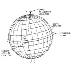
Spacecraft orbit of Landsat 1, 2, and 3.

This schematic appears in The Landsat Tutorial Workbook: Basics of Satellite Remote Sensing, written by Dr. Nicholas Short and published by the NASA Scientific and Technical Information Branch in 1982.
Dr. Short writes, “The Landsat-1 spacecraft was launched on July 23, 1972, and positioned in the orbit shown in [this figure]. Landsat-2 was launched on June 22, 1975, and Landsat-3 was launched on March 5, 1978.
“These satellites [had] a nominal altitude of 917 km (570 miles); 99° orbital inclination, which makes them nearly polar; and a sun-synchronous orbit, which means that the orbit plane precesses about the Earth at the same angular rate that the Earth moves about the Sun. This feature enables the spacecraft to cross the Equator at the same local time (about 9:30 to 10:00 a.m.) on the sunlit side of the Earth.”

Post Last Updated on January 22, 2013
On Key

Recent Posts

Space Oblique Mercator Projection

To continually map the Earth’s surface using Landsat data, an entirely new projection had to be created. This new projection was created by John Parr Snyder and is known as the Space Oblique Mercator (SOM) projection. This projection has been referred to as, “one of the most complex projections ever devised” by Library of Congress cartographic historian, John W. Hessler.

Read More »

Seasonal Illumination Variations

Source: Landsat-6 Programming and Control Handbook This schematic appears in the Landsat-6 Programming and Control Handbook that was prepared by Martin Marietta Astro Space in 1993. Like all of the Landsat satellites,

Read More »

Transverse Mercator Projection

Source: 1983 Landsat Short Course Lecture This schematic appears in the handbook that accompanied the1983 Landsat Short Course lecture on “TM Data Processing and Correction” that was given by Jeff Dozier

Read More »
On Key

Related Posts

Space Oblique Mercator Projection

To continually map the Earth’s surface using Landsat data, an entirely new projection had to be created. This new projection was created by John Parr Snyder and is known as the Space Oblique Mercator (SOM) projection. This projection has been referred to as, “one of the most complex projections ever devised” by Library of Congress cartographic historian, John W. Hessler.

Read More »

Seasonal Illumination Variations

Source: Landsat-6 Programming and Control Handbook This schematic appears in the Landsat-6 Programming and Control Handbook that was prepared by Martin Marietta Astro Space in 1993. Like all of the Landsat satellites,

Read More »