Seasonal Illumination Variations

Seasonal Illumination Variations

Source: Landsat-6 Programming and Control Handbook

Schematic diagram illustrating the seasonal illumination variations on a sun-synchronous orbit.

This schematic appears in the Landsat-6 Programming and Control Handbook that was prepared by Martin Marietta Astro Space in 1993.
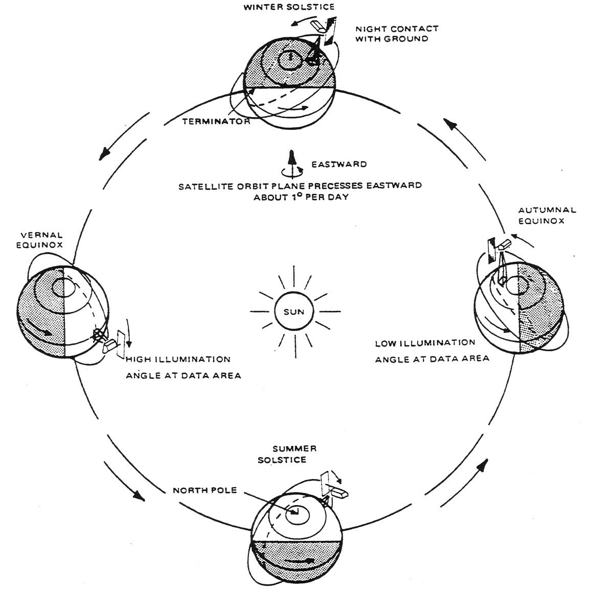
Like all of the Landsat satellites, Landsat-6 would have been in a sunscreen orbit had its launch been successful.
The L6 Handbook tells us, “Establishment of the sun-synchronous orbit provides for minimal variation of solar illuminations at the spacecraft and at the observed Earth scene. This occurs because of the near constancy of the geometry between the orbit plane and the sun vector. By achieving the correct combinations of altitude and orbit inclination, the orbit will precess about the geographic North Pole in the same direction (west to east) and at the same annual rate as the apparent Sun’s motion relative to the Earth. The geometry of the orbit-Earth-Sun relationship by season is shown in [this figure]. This figure also indicates how ground scene illumination is affected by changes in season. Such seasonal variations also have an impact on illumination at the spacecraft.”

Post Last Updated on January 22, 2013
On Key

Recent Posts

Space Oblique Mercator Projection

To continually map the Earth’s surface using Landsat data, an entirely new projection had to be created. This new projection was created by John Parr Snyder and is known as the Space Oblique Mercator (SOM) projection. This projection has been referred to as, “one of the most complex projections ever devised” by Library of Congress cartographic historian, John W. Hessler.

Read More »

Landsat Spacecraft Orbit

Source: The Landsat Tutorial Workbook This schematic appears in The Landsat Tutorial Workbook: Basics of Satellite Remote Sensing, written by Dr. Nicholas Short and published by the NASA Scientific and Technical

Read More »

Transverse Mercator Projection

Source: 1983 Landsat Short Course Lecture This schematic appears in the handbook that accompanied the1983 Landsat Short Course lecture on “TM Data Processing and Correction” that was given by Jeff Dozier

Read More »
On Key

Related Posts

Space Oblique Mercator Projection

To continually map the Earth’s surface using Landsat data, an entirely new projection had to be created. This new projection was created by John Parr Snyder and is known as the Space Oblique Mercator (SOM) projection. This projection has been referred to as, “one of the most complex projections ever devised” by Library of Congress cartographic historian, John W. Hessler.

Read More »

Landsat Spacecraft Orbit

Source: The Landsat Tutorial Workbook This schematic appears in The Landsat Tutorial Workbook: Basics of Satellite Remote Sensing, written by Dr. Nicholas Short and published by the NASA Scientific and Technical

Read More »