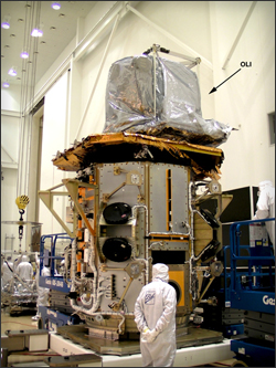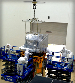
Engineers at Orbital Sciences Corporation, Gilbert, AZ mechanically integrated the Operational Land Imager (OLI) onto the Landsat Data Continuity Mission (LDCM) spacecraft. The integration took 3 days. This top photo shows OLI wrapped in electrostatic discharge blankets that also provide a barrier to particulate contamination. The lifting frame in the photo was removed after integration. Engineers attached the instrument to the spacecraft payload deck at different three mounting feet.
OLI images will cover wide areas of the Earth’s landscape while providing sufficient resolution to distinguish features like urban centers, farms, forests and other land uses. The OLI will provide Earth-imaging at 15-meter (49 ft.) panchromatic and 30-meter multispectral spatial resolutions along a 185 km (115 miles)-wide swath. The entire Earth will fall within view of the OLI once every 16 days from the near-polar LDCM orbit. Orbital Sciences Corporation is building the LDCM spacecraft that will carry a two-sensor payload, the OLI and a Thermal Infrared Sensor (TIRS), into space when launched in December 2012. Ball Aerospace & Technologies Corp., Boulder, Colo. built OLI. NASA Goddard Spaceflight Center is managing the mission and building the TIRS instrument. Goddard plans to ship TIRS to Orbital Space Science Corporation in late January.

Further Information:
+ OLI Integration
+ NASA LDCM website

Be Part of What’s Next: Emerging Applications of Landsat at AGU24
Anyone making innovative use of Landsat data to meet societal needs today and during coming decades is encouraged to submit and abstract for the upcoming “Emerging Science Applications of Landsat” session at AGU24.


