
By Madeleine Gregory
Rising sea levels and increased ocean temperatures are supercharging hurricanes. Alongside damage to human communities, these violent storms devastate forest ecosystems; storm surge, heavy rainfall, high winds, and inland flooding can lead to tree loss, soil erosion, and habitat destruction. Monitoring vulnerable ecosystems before and after disasters can be critical for restoration efforts.
In research presented at the 2024 annual meeting of the American Geophysical Union, University of Florida Postdoc Associate Caiwang Zheng and Oak Ridge National Laboratory Postdoctoral Research Associate Tianqi Zhang analyzed Florida’s forests before and after Hurricanes Helene and Milton. By integrating LiDAR data from ICESat-2 with multispectral observations from Harmonized Landsat Sentinel (HLS), Zheng and Zhang made maps of vulnerability to hurricane damage.
What is one major takeaway from your research?
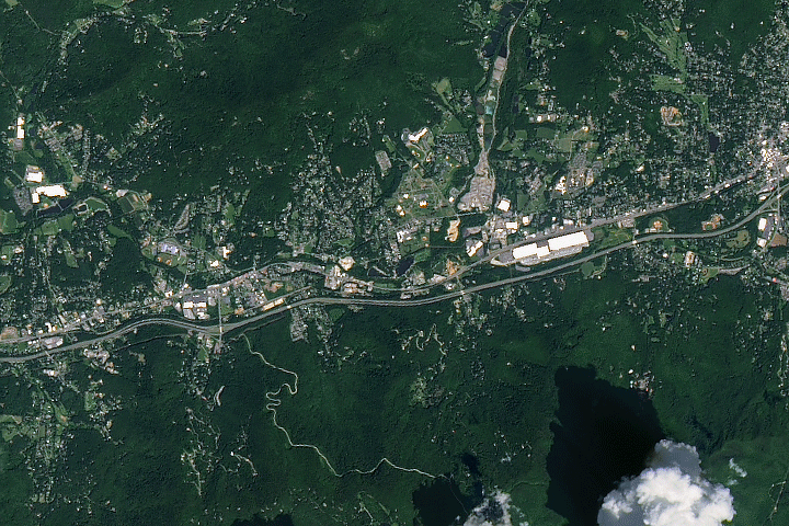
In 2024, Florida experienced two significant hurricanes: Hurricane Helene on September 26 and Hurricane Milton on October 9. Hurricane Milton made landfall on Florida’s west coast as a Category 5 storm, making it one of the strongest hurricanes in the state’s history. It caused extensive damage to Florida’s natural environment, particularly devastating tree cover. The Tampa Bay area suffered the loss of thousands of trees, which disrupted local ecosystems and affected residents’ daily lives.
This study utilized multi-source remote sensing imagery and machine learning techniques to assess the extent of forest damage caused by Hurricane Milton on the west coast of Florida. By combing ICESat-2 LiDAR data with Harmonized Landsat Sentinel-2 (HLS) optical and multispectral observations, we conducted a analysis of changes in canopy height and ecosystem structure in Florida’s west coastal regions before and after the hurricanes. This integrated approach enhances our understanding of the spatial distribution and severity of large-scale forest destruction. The resulting vulnerability maps are valuable for improving predictions and mitigation strategies, especially as climate change intensifies tropical cyclone activity.
Why did you use HLS in this work? Did it give you any insight that would have been difficult to get otherwise?
The HLS product is a high-quality Earth observation dataset that combines data from NASA/USGS Landsat 8/9 and Sentinel-2A/B satellites, providing surface reflectance data at 30-meter resolution every 2-3 days with a historical archive spanning decades. This high temporal frequency is critical for assessing vegetation health, biomass changes, and rapid surface alterations before and after natural disasters like hurricanes.
How did blending Landsat and ICESat-2 data help you to perform this research?
The ICESat-2 satellite, equipped with the Advanced Topographic Laser Altimeter System (ATLAS), provides precise measurements of forest canopy heights. However, ICESat-2’s observations are limited to narrow ground tracks along the satellite’s orbit, leading to spatial coverage limitations. Furthermore, ICESat-2’s 91-day repeat cycle does not provide sufficient temporal resolution necessary for monitoring rapid changes, such as those caused by hurricanes, within the same region. While the integration of ICESat-2 and Landsat/HLS data has been extensively studied for mapping canopy height (Xi et al., 2022; Lang et al., 2023; Silva et al., 2023; Goel et al., 2025), we aim to extend this approach for a preliminary assessment of hurricane-induced damage in Florida following Hurricane Milton.
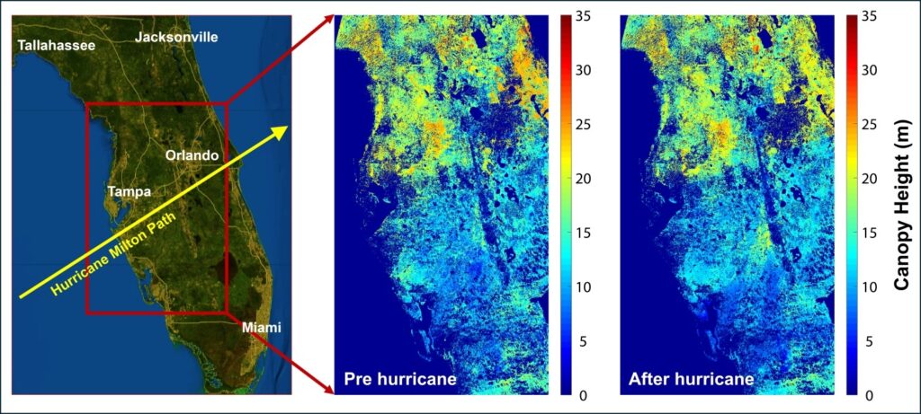
By integrating ICESat-2’s accurate but spatially limited canopy height measurements with the extensive spatial and temporal coverage of HLS spectral data, we built machine learning models to predict canopy heights across broader areas. This approach involves training models to recognize relationships between spectral signatures in HLS data and canopy heights measured by ICESat-2. Once trained, these models were used to estimate canopy heights in regions not directly measured by ICESat-2, effectively bridging the spatial gaps.
We employed this approach to evaluate changes in forest canopy height before and after Hurricane Milton, enabling a detailed assessment of forest damage at a fine scale. The high temporal resolution of HLS data ensures the availability of imagery both pre- and post-hurricane, offering valuable insights into the resilience and vulnerability of various forest regions. Understanding forest responses to disturbances like hurricanes is crucial for predicting ecosystem dynamics under global environmental change. Accurate forest damage assessments can inform the development of effective management and conservation strategies. Moreover, integration of ICESat-2 and HLS data exemplifies the potential of multi-source remote sensing to address individual data limitations, enhancing our capacity to monitor and manage forest ecosystems globally.
Are there any research questions you’re interested in that build off of this work?
Enhancing machine learning models for canopy height estimation and conducting long-term monitoring of forest ecosystem health are crucial research areas for advancing forest management and conservation. By incorporating variables such as terrain information, climate data, and soil characteristics, and leveraging advanced algorithms, including deep learning techniques, the predictive accuracy of canopy height estimation models may be substantially improved, particularly across diverse forest types and conditions. Additionally, utilizing historical Landsat archives and observational data from ICESat-2 enables the development of robust methods for analyzing long-term trends in canopy height and biomass. This approach is especially valuable for studying the recovery dynamics of hurricane-damaged forests in Florida over the years and for assessing the resilience of forest ecosystems.
First Author:
Caiwang Zheng
Postdoc Assoicate, University of Florida
Co-Author:
Tianqi Zhang
Postdoc Assoicate, Oak Ridge National Laboratory
Reference:
Xi, Z., Xu, H., Xing, Y., Gong, W., Chen, G., & Yang, S. (2022). Forest canopy height mapping by synergizing icesat-2, sentinel-1, sentinel-2 and topographic information based on machine learning methods. Remote Sensing, 14(2), 364.
Lang, N., Jetz, W., Schindler, K., & Wegner, J. D. (2023). A high-resolution canopy height model of the Earth. Nature Ecology & Evolution, 7(11), 1778-1789.
Silva, C., Atkins, J., Cannon, J., Hudak, A. T., Schlickmann, M. B., Rocha, K. D., … & Klauberg, C. (2023, December). Fusing NASA’s ICESat-2 and Landsat 8 OLI data to assess forest recovery post-hurricane disturbance in Southern forests. In AGU Fall Meeting Abstracts (Vol. 2023, No. 1795, pp. B51D-1795).
Goel, A., Song, H., & Jung, J. (2025). Integrating Sparse LiDAR and Multi-Sensor Time Series Imagery from Spaceborne Platforms for Deriving Localized Canopy Height Model. IEEE Transactions on Geoscience and Remote Sensing.


