Monitoring Natural Resources on Native American Reservations

Monitoring Natural Resources on Native American Reservations

cattle grazing
Cattle grazing on the Rosebud Indian Reservation near Olsonville, South Dakota. Photo credit: USDA


During a visit with Confederated Salish Kootenai Tribe leaders of Montana’s Flathead Indian Reservation today, Department of the Interior Secretary Sally Jewell issued a Secretarial order reaffirming the land trust responsibilities of the Interior Department to Native tribes and individuals.


“This Order reaffirms the Department’s obligations and demonstrates our continuing commitment to upholding the important federal trust responsibility for Indian Country,” Secretary Jewell said. “It acknowledges that each of us working in the federal government has an important responsibility to Indian country and it ultimately takes all of us, working together, to meet our important obligations as a trustee.”


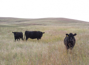
Exactly two years ago, David Bartecchi, a community rights specialist, published an article in Village Earth explaining how free Landsat data can help Native Americans monitor the more than 55 million acres of their land held in land trusts by the Bureau of Indian Affairs.


Bartecchi’s article chronicles the history of land-leasing and provides tips on how overgrazing can be identified and stopped—an example of free data empowering land stewardship and rectification of perceived injustices.

Further Information:
+ Secretary Jewell Issues Secretarial Order Affirming American Indian Trust Responsibilities
+ Monitoring Natural Resources on Native American Reservations, Village Earth

Get the latest from Landsat in your inbox.


By submitting this form, you are consenting to receive marketing emails from: Landsat Science. You can revoke your consent to receive emails at any time by using the SafeUnsubscribe® link, found at the bottom of every email. Emails are serviced by Constant Contact
On Key

Recent Posts

Map shows South Korea with waterways highlighted. In the top right corner is a north arrow and in the bottom left corner is a legend of different rivers in South Korea.

Monitoring Water Quality in South Korea

South Korea is facing a water quality problem. Researchers Hyunglok Kim and Seongjun Lee from the Gwangju Institute of Science and Technology (GIST) embarked on developing a model to predict water quality indicators in near real-time.

Read More »
Landsat outreach specialist Allison Nussbaum and GEDI/UMD Faculty Specialist Talia Schwelling hold Landsat/GEDI postcards at the NASA exhibit booth at AGU24.

Landsat at AGU24

The NASA Landsat Science and Outreach teams attended the American Geophysical Union’s annual meeting in DC in December. At AGU24, they shared research and educated the public about Landsat.

Read More »
On Key

Related Posts

Map shows South Korea with waterways highlighted. In the top right corner is a north arrow and in the bottom left corner is a legend of different rivers in South Korea.

Monitoring Water Quality in South Korea

South Korea is facing a water quality problem. Researchers Hyunglok Kim and Seongjun Lee from the Gwangju Institute of Science and Technology (GIST) embarked on developing a model to predict water quality indicators in near real-time.

Read More »