By Laura E. Rocchio

Farming is a risky business. A farmer must deal with the precarious nature of the weather, the volatility of commodity prices, the perils of insects and disease, all so that you and I can eat.
The U.S. Department of Agriculture (USDA) helps farmers manage their risks through the Federal Crop Insurance Program. But through the years, fraud and abuse by a small percentage of farmers has put this essential program in jeopardy, so the government has had to seek stricter enforcement methods. Enter Landsat data.
Armed and armored with Landsat data
“Landsat has played a major role in shifting the tide of fraud cases,” says Dr. John Brown, an agricultural private investigator, from a home office in Columbia, MO, where he analyzes Landsat satellite images of farms suspected of fraudulent insurance claims.
Landsat imagery is typically employed if a USDA field investigator determines that claim verification is warranted. The image investigation is performed either internally by the USDA’s Risk Management Agency (RMA) or contracted out to a private remote sensing expert like Brown.
Over the past three years, the RMA has used an average of 600 Landsat scenes per year (each covering a geographic area of 7.6 million acres) for investigative purposes. Typically, about half of the Landsat image analyses support a farmer’s insurance claim and half indicate fraud.
“The overwhelming majority of the American farmers who buy crop insurance are honest,” says Dr. Jim Hipple, a remote sensing and GIS advisor with the RMA. A statement supported by a joint study done by the Center for Agribusiness Excellence at Tarleton State University and the RMA’s Strategic Data Acquisition and Analysis unit. The study estimates fraudulent activity as only 0.18% of insured farmers.
“The instances where Landsat highlights egregious fraud are important, but there are also many times when the use of Landsat supports a producer’s claim of an insurable loss – a situation where the forces of disease, drought, and weather looked out of the norm,” says Hipple.
Brown too understands the farmers’ lifestyle and the hardships of their trade, so he considers his crop investigation work highly important.
“Farmers rely on the insurance safety for risk management, so fraud hurts everyone,” Brown says.
Landsat and the investigation
When Brown is hired to investigate a questionable claim, he looks for evidence of whether or not a farmer actually planted or harvested what was asserted. If the Landsat image does not support the farmer’s insurance claim, then Brown will testify to that fact in court.
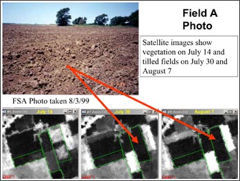
Brown has testified as an expert witness 26 times solving over $50 million in crop fraud cases, mainly for the government. In some cases, Brown is able to show that a field that a farmer claimed had failed was never even plowed.
“A Landsat image catches them in the act,” Brown says, referring to both the bi-monthly Landsat image acquisition schedule and the robust U.S. Landsat data archive.
Hipple explains, “because fraud does not occur in a predictable pattern, and those who commit fraud may try to hide or cover-up the fraud, we need a data source of adequate spatial resolution (30-meters or better) that systematically images the entire continental U.S., Alaska, Hawaii, and Puerto Rico – places where crop insurance is available.”
Success using Landsat data to support program compliance has prompted the RMA to train their compliance investigators in image analysis. These analyses can mean a sizable cost savings for the U.S. government, who no longer has to underwrite as many fraudulent claims.
“A conservative estimate would be that Landsat saves the U.S. government $100 million per year,” says Brown.
“More importantly, the criminals now know they are being watched,” Brown surmises. In regions where Brown has testified, the number of claims has dropped, the number of appeals has diminished, the overall number of fraud cases has declined, mediation settlements have increased, and farmers have even come into USDA offices to admit guilt.
Brown testifies in cases across the nation involving cotton, sorghum, tomato, soybean, and corn crops among others. He sees his work as key to restoring integrity to the farming industry.
Recently, Brown testified in a Vernon, Texas case in which the defendant was found guilty of defrauding the government of $9 million.
“These bad guys are creating higher insurance premiums and a bad name for farmers,” Brown says.
Weeding out fraud
Such cases of multi-million dollar insurance fraud precipitated the Agriculture Risk Protection Act (ARPA) legislation. Passed by the U.S. Congress in 2000, this law was created to help stem the waste, fraud and abuse that were evident within the crop insurance program. The act stated that data mining technologies and tangible punishments, such as jail time and restitution, should be employed to improve program compliance.
Since ARPA has been enacted, suspect farmers are reported to the USDA and sent a letter to let them know they are on a watch list. In order to prosecute a farmer with an anomalous claim, an investigation must be done. Satellite imagery, such as Landsat, is often used to determine if the imagery of the ground matches the farmer’s claim.
Landsat as evidence

When Landsat data are used as evidence in a courtroom there are two main challenges: an expert witness must be able to convince a jury unfamiliar with remotely sensed imagery to trust Landsat data and the prosecution must assure that the judge admits the Landsat images as evidence into the courtroom – a legal protocol known as the Daubert Challenge.
Brown gives a brief presentation explaining what a Landsat satellite is and how it works so that jurors can understand and trust Landsat data. And, it is relatively easy for Brown to mount a Daubert Challenge given the wealth of scientific literature documenting Landsat data usage, the sensor’s unparalleled calibration standards, and an abundance of proven data analysis methods.
“The history of Landsat applications in agriculture is strong, therefore, I have numerous scientific protocols that are accepted in the scientific community and readily accepted in court,” Brown says.
Brown’s background
Brown found his way into the courtroom as an expert witness and agricultural private investigator after years of scientific training and agricultural work.
“As a scientist you learn how to investigate,” says Brown, who has had a lifelong interest in agriculture and once owned a forage farm. He grew up working on his grandfather’s dairy farm and went on to earn three degrees in agricultural disciplines.
During his dissertation, Brown worked extensively with Magnetic Resonance Imaging (MRI), a imaging technique used extensively in the medical field, to investigate plant water relationships and root hydrodynamics.
After earning his Ph.D., Brown applied his experience with imaging science to aerial image analysis and in 1993 started the Agricultural Investigation and Research Corporation (AIR Corp).
AIR Corp specializes in analysis of both aerial photography and satellite imagery. Crop insurance fraud investigations make up only a fraction of AIR Corp’s business; the company also uses Landsat to help farmers do crop health analysis, property damage assessments, and water rights establishment.
Technical details
Skills that are needed as a satellite-imagery farm detective include computer capability, an understanding of math, experience with crop and animal production and the ability to visualize numbers into evidence that a jury can easily understand.
Typically, Brown can do the Landsat imagery analysis necessary for a fraud case in a day or less. The 30-meter spatial resolution of Landsat data is adequate for 95% of Brown’s investigation work. The number of Landsat scenes Brown uses depends on the case; in some instances, one is enough. The smallest area that Brown can reliably investigate with Landsat data is five acres (the size of many vegetable fields on the east coast).
Like problems with any visible imagery, Brown must contend with cloud cover, cloud shadow, and terrain shadow during his Landsat image analysis. Brown uses Landsat 7 data collected after May 2003 sparingly because the triangular wedges of missing data on the image sides (caused by an on-board mechanical failure) make the admissibility of the data in court questionable. Brown will only use such Landsat 7 data if the field in question is large and the scan gaps do not affect his research.
But by and large, Landsat data play a critical role in agricultural fraud investigations because of Landsat’s thorough coverage over the U.S. (thanks to the eight-day repeat-cycle between Landsat 5 and Landsat 7) and the well-populated Landsat data archive.
Hipple affirms that the Landsat program is important given, “the repeatability, the spatial resolution, a spectral coverage that is ideal for examining vegetation, and the high quality of both the geometric and radiometric properties of the imagery.”
Landsat “stops time,” as Brown puts it, giving investigators the data they need to stop fraud.


