The Multispectral Scanner System (MSS) sensors were line scanning devices observing the Earth perpendicular to the orbital track. The cross-track scanning was accomplished by an oscillating mirror; six lines were scanned simultaneously in each of the four spectral bands for each mirror sweep. The forward motion of the satellite provided the along-track scan line progression.
The first five Landsats carried the MSS sensor which responded to Earth-reflected sunlight in four spectral bands. Landsat 3 carried an MSS sensor with an additional band, designated band 8, that responded to thermal (heat) infrared radiation.
An MSS scene had an Instantaneous Field Of View (IFOV) of 68 meters in the cross-track direction by 83 meters in the along-track direction (223.0 by 272.3 feet respectively). To understand this concept consider a ground scene composed of a single 83 by 83 meter area. The scan monitor sensor ensures that the cross-track optical scan is 185 km at nominal altitude regardless of mirror scan nonlinearity or other perturbations of mirror velocity.
Cross- track image velocity was nominally 6.82 meters per microsecond. After 9.958 microseconds, the 83 by 83 meter image has moved 67.9 meters. The sample taken at this instant represented 15 meters of previous information and 68 meters of new information.
Therefore, the effective IFOV of the MSS detector in the cross-track direction was considered to be 68 meters which corresponds to a nominal picture element (pixel) ground area of 68 by 83 meters at the satellite nadir point. Using the effective IFOV in area calculation eliminates the overlap in area between adjacent pixels.
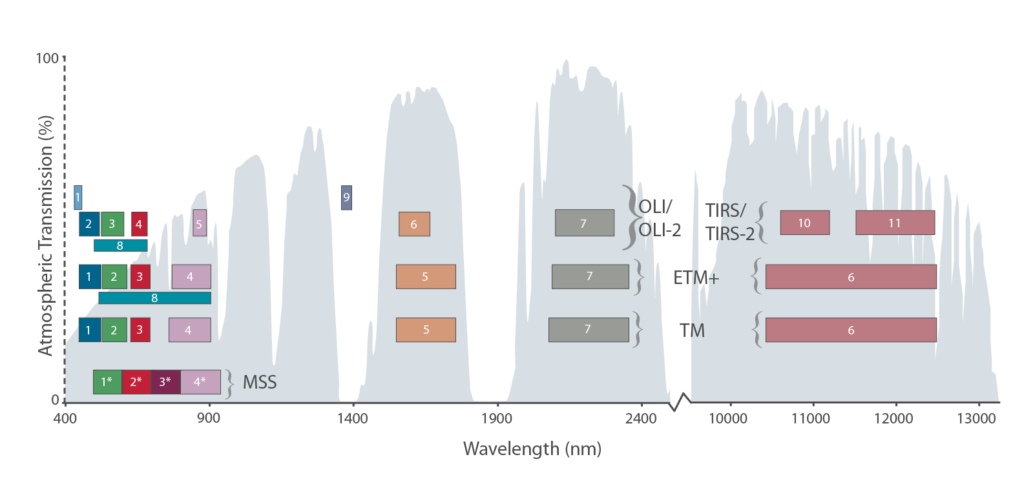
MSS Bands
| Band # (L1-L2) | Band # (L3) | Band # (L4-L5) | µm | Resolution* | L4/L5 TM Band Equivalent |
|---|---|---|---|---|---|
| 4 | 4 | 1 | 0.5-0.6 | 68 m X 83 m | ~ 2 (0.52–0.60 µm) |
| 5 | 5 | 2 | 0.6-0.7 | 68 m X 83 m | ~ 3 (0.63–0.69 µm) |
| 6 | 6 | 3 | 0.7-0.8 | 68 m X 83 m | ~ 4 (0.76–0.90 µm) |
| 7 | 7 | 4 | 0.8-1.1 | 68 m X 83 m | ~ 4 (0.76–0.90 µm) |
| N/A | 8 | N/A | 10.4-12.6 | 68 m X 83 m | ~ 6 (10.41-12.5 µm) |
MSS Technical Specifications
- Sensor type: opto-mechanical
- *Spatial Resolution: 68 m X 83 m (commonly resampled to 57 m, or 60 m)
- Spectral Range: 0.5 – 1.1 µm
- Number of Bands: 4, 5 (Landsat 3 only)
- Temporal Resolution: 18 days (L1-L3), 16 days (L4 & L5)
- Image Size: 185 km X 185 km
- Swath: 185 km
- Programmable: no