Thinking on the Socioeconomic Impacts of Data Democracy

Thinking on the Socioeconomic Impacts of Data Democracy

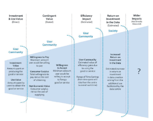
diagram about social benefits of data
From the report: a diagram showing the range of approaches for considering societal benefits. Credit: Beagrie and Houghton, 2014
If the impact that data democracy and the knowledge commons has on society is of interest to you, you’ll be interested to know that USGS has published an Open Report of the Workshop on Assessing the Impact and Value of Open Geospatial Information.
The two-day workshop was held at George Washington University in Washington, D.C. on October 28 and 29, 2014 and was sponsored by USGS, NASA, Colorado University, IEEE-USA, the Space Policy Institute, and George Washington University. Sixty-eight participants attended representing U.S. public and private sectors, academia, nongovernmental agencies and international organizations.
During the workshop there were three keynotes, a panelist dialogue on perspectives, an interactive discussion about data impacts on decision making, and four panel sessions where position papers were given and the panel members shared their own specific views on those papers.
The panel session topics included:

  1. Impact of increased access to data and new modes of consumption—position paper by John Houghton from the Center for Strategic Economic Studies at Victoria University in Melbourne, Australia.
  2. Increased supply of geospatial information and expanded participatory processes in the production of data (such as crowdsourcing)—position paper by Lea Shanley, a Presidential Innovation Fellow at NASA/University of Wisconsin–Madison and Max Craglia from the European Commission–Joint Research Center
  3. Emerging approaches for economic impact assessments—position paper by Richard Bernknopf from the University of New Mexico and Carl Shapiro from USGS.
  4. Emerging issues for societal impact assessments—position paper by Bridgette Wessels from the University of Sheffield, UK and Max Craglia, EC-JRC

Note: the workshop defined data democracy as increased participation in the production and use of data.
+ Read the full report.

Get the latest from Landsat in your inbox.


By submitting this form, you are consenting to receive marketing emails from: Landsat Science. You can revoke your consent to receive emails at any time by using the SafeUnsubscribe® link, found at the bottom of every email. Emails are serviced by Constant Contact
On Key

Recent Posts

Map shows South Korea with waterways highlighted. In the top right corner is a north arrow and in the bottom left corner is a legend of different rivers in South Korea.

Monitoring Water Quality in South Korea

South Korea is facing a water quality problem. Researchers Hyunglok Kim and Seongjun Lee from the Gwangju Institute of Science and Technology (GIST) embarked on developing a model to predict water quality indicators in near real-time.

Read More »
Landsat outreach specialist Allison Nussbaum and GEDI/UMD Faculty Specialist Talia Schwelling hold Landsat/GEDI postcards at the NASA exhibit booth at AGU24.

Landsat at AGU24

The NASA Landsat Science and Outreach teams attended the American Geophysical Union’s annual meeting in DC in December. At AGU24, they shared research and educated the public about Landsat.

Read More »
On Key

Related Posts

Map shows South Korea with waterways highlighted. In the top right corner is a north arrow and in the bottom left corner is a legend of different rivers in South Korea.

Monitoring Water Quality in South Korea

South Korea is facing a water quality problem. Researchers Hyunglok Kim and Seongjun Lee from the Gwangju Institute of Science and Technology (GIST) embarked on developing a model to predict water quality indicators in near real-time.

Read More »