Dr. Bin Chen is a postdoctoral scholar at University of California, Davis. Here is what Bin shared with us about the work he is presenting today at #AGU18:
An Automatic Mapping of Tree Crops Planting Age Using Landsat Time Series Stacks and Google Earth Engine
What are the major findings of this research?
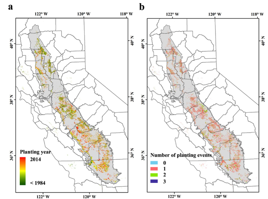
We proposed an efficient and robust detection method to track crop cover dynamics and identify the planting year through time series of Landsat imagery within the Google Earth Engine (GEE) platform. Our method showed a very high accuracy of estimating tree crop ages, with a R2 of 0.96 and a mean absolute error of less than half a year, when compared with 142 records provided by almond growers. We further generated the statewide mapping of planting years for all fruit and nut trees in California with an overall accuracy of 89.2%.
What are the implications of your findings?
California’s Central Valley faces serious challenges of water scarcity and degraded groundwater quality due to nitrogen leaching. Orchard age (i.e., planting year) is one of the key determinants for fruit and nut production and directly affects consumptive water use and fertilizer demand. Thus, our generated statewide mapping of planting years of all fruit and nut trees will be very useful in agricultural management.
Meanwhile, this automatic cloud-based application will be integrated with our yield prediction tool to facilitate growers and other stakeholders to adopt a data-driven approach to achieve agriculture sustainability.
What insight did you gain from Landsat that would have been difficult to ascertain otherwise?
Due to the obvious land cover change from bare land to vegetation (or from vegetation to bare land), new planting events (or vegetation removing events) of fruit and nut trees can be reflected from multi-temporal remote sensing observations. The relatively long time series of NDVI from the Landsat multispectral imagery with a moderate spatial resolution (30 m) makes it possible to track annual dynamics of agricultural planting activities over the past three decades, thereby providing an intuitive and cost-efficient alternative to previous direct and indirect methods of planting age estimations.
Do you foresee Landsat data being used as part of an operational agriculture app for nutrient and water management?
Yes, sure. As a first step of our California Department of Food and Agriculture (CDFA)-funded project to yield prediction and thus fertilize input, this Landsat-based work will be integrated with an interactive Yield Calculator app to provide end users with timely block-level yield estimate for resource management decision, and it will also be coupled with the widely used Nitrogen Calculator to guide the block-level N management.
Co-authors:
Dr. Yufang Jin
University of California, Davis
Dr. Patrick Brown
University of California, Davis
This work was supported by a project (SCB16036) funded by USDA California Department of Food and Agriculture (CDFA) Specialty Crop Block Grant Program.
Anyone can freely download Landsat data from the USGS EarthExplorer or LandsatLook.
Further Reading:
+ Landsat at #AGU18

