

Unleashing Climate Data and Innovation for more Resilient Ecosystems
Ecosystems provide vast services and benefits to humankind: food and water that is needed for survival; nutrients and other natural products that fuel farms and industries; natural controls on many pests and pathogens; storage of carbon safely out of the atmosphere; shared spaces for tourism and recreation; and sanctuaries that preserve biodiversity, natural beauty, and cultural history.
Mapping South Asia's Mangroves
Along the sea’s edge in Bangladesh, India, Pakistan, and Sri Lanka, the dense coastal population lives largely in symbiosis with the region’s mangrove forests.
Mangroves—a vast network of intertidal trees and shrubs with their characteristic tangle of above ground roots—give safety, sustenance, and spectacle to coastal denizens in a multitude of ways. Namely, by stabilizing shorelines, safeguarding water quality, influencing stable microclimates, controlling flooding, and providing transportation, forest products, hunting and fishing grounds, and recreation and protecting people and property from storms.
Dinosaur GPS
Dr. Robert Anemone is the head of the Department of Anthropology at the University of North Carolina at Greensboro. But he works out of a pretty standard office. The administrative assistant greets you in the outer office before gesturing toward the next door.
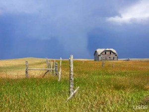
Modeling a Changing American Landscape
Land change is a signature activity of human civilization. Since the dawn of history, people have purposefully converted natural landscapes to human-dominated areas. Typical motivations for land change are cultivation (e.g. slash-and-burn fields, rice paddies, modern farms); occupation (villages, cities, housing developments); and other cultural and economic pursuits (roads, schools, airports).
Tracking Giant Kelp From Space
Citizen scientists worldwide are invited to take part in marine ecology research, and they won’t have to get their feet wet to do it. The Floating Forests project, an initiative spearheaded by scientists at UC Santa Barbara and UCLA, is calling on would-be researchers to examine 30 years of satellite photographs of coastal kelp-dominated areas around the globe to help identify their various sizes and locations.
A Closer Look at Old-Growth Forest Loss in Indonesia
A group of researchers from the University of Maryland, the Indonesian Ministry of Forestry, and the World Resource Institute joined forces to remedy the lack of consensus about the amount of old-growth forest clearing occurring in Indonesia.
