

Landsat Backbone of Forest Monitoring
In a recent EarthSky interview, Landsat science team member Curtis Woodcock talks about the importance of Landsat data to global forest monitoring. Podcasts: • 90 second podcast interview (1.7 Mb) • 8 min.
Free Landsat Data = More Deforestation Monitoring
Matt Hansen, the co-director of South Dakota State University’s Geographic Information Science Center for Excellency, spoke with Mongabay.com about the importance of Landsat data to forest cover monitoring. The historical Landsat database
Most New Farmland Comes from Cutting Tropical Forest
Source: Louis Bergeron, Stanford Report A new study led by a Stanford researcher shows that more than 80 percent of the new farmland created in the tropics between 1980 and 2000
Root of the Matter: A New Map Shows Decline of Life-Saving Forests
Contributor: Gretchen Cook-Anderson, NASA‘s Earth Science News Team Countless people clung to life in the branches of trees hemming the shorelines during the deadly 2004 tsunami that killed more than 230,000
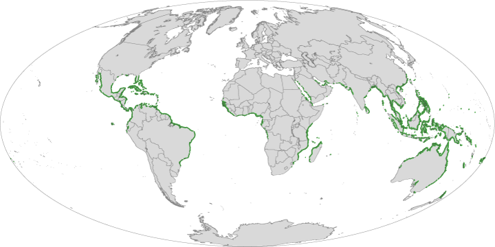
Landsat Enables World’s Most Comprehensive Mangrove Assessment
The most definitive map of Earth’s mangrove forests has been created with Landsat data. A group of scientists, led by Chandra Giri from USGS-EROS, has calculated that approximately 53,190 square
Landsat Time Series Used to Map Tropical Dry Forest Height
A team of researchers led by Landsat Science Team member Eileen Helmer has used Landsat time series data to map forest height on the island of Eleuthera. In the past,
