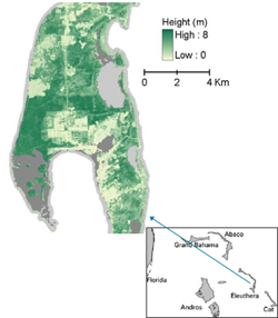
A team of researchers led by Landsat Science Team member Eileen Helmer has used Landsat time series data to map forest height on the island of Eleuthera. In the past, forest height and vertical structure have more typically been mapped with lidar data, but limited lidar data availabilty make this Landsat-based approach—using widely and freely available Landsat data—an important innovation.

Helmer and her team used a time series of cloud-cleared Landsat and Advanced Land Imager (ALI is the precursor to LDCM’s Operational Land Imager) to map forest disturbance type and age as well as forest vertical structure in an effort to better understand the avian habitat of Eleuthera, home to the endangered Kirtland’s Warbler.
The Bahaman island of Eleuthera is persistently cloud-covered. Only one near-perfectly clear Landsat image exists for the study area. So, creating cloud-cleared images was central to this work. The cloud-cleared images were created using mosaics of the clear portions of many images. The mosaic creation was aided by the Landsat archive co-registered products.
By comparing spectral information from eight different time periods, the researchers were able to indirectly obtain forest height. This was possible because as new trees grow after a forest disturbance their spectral response (the light they reflect) changes as they become more dense and tall. So in the Eleuthera environment (a subtropical dry forest growing on a limestone bedrock) substituting time for a direct measurement of vertical canopy structure is possible.
Adding 12-bit ALI data (i.e., data that discerns 4096 levels of reflection instead of 256 levels) to the time series improved the study results. This means that the 12-bit OLI data from the future LDCM will, together with the rich historical Landsat data archive, improve this type of forest vertical structure mapping.
Using cloud-cleared images allowed land cover and forest disturbance type and age to be mapped simultaneously. The authors suggest that the Landsat archive should include cloud-cleared imagery for places where persistent cloud cover is an issue.
Reference:
Helmer, E.H., et al.(2010), Mapping tropical dry forest height, foliage height profiles and disturbance type and age with a time series of cloud-cleared Landsat…, Remote Sensing of Environment, doi:10.1016/j.rse.2010.05.021

Be Part of What’s Next: Emerging Applications of Landsat at AGU24
Anyone making innovative use of Landsat data to meet societal needs today and during coming decades is encouraged to submit and abstract for the upcoming “Emerging Science Applications of Landsat” session at AGU24.


