
USGS Landsat Newsletter Published
The USGS Landsat Newsletter (vol. 1, issue 1, 2007) has been published on the USGS Landsat website. Its content includes: Landsat Science Team Meeting held January 9-11, 2007 Landsat in Everyday Places
Rainforest Monitoring Improved by Data Fusion
In late April, Science magazine reported that Brazil is a world leader in tropical forest monitoring thanks to their use of data from a number of Earth-observing satellites. Brazil’s Instituto
LTWG-16 Meeting Held in Brazil
Contributor: Terry Arvidson The 16th Landsat Technical Working Group (LTWG) meeting was held in Brazil May 14-18, 2007. The meeting was organized by USGS and hosted by the Instituto Nacional
NASA Awards LDCM Accommodation Study
NASA Goddard Space Flight Center’s Rapid Spacecraft Development Office (RSDO) awarded delivery orders to four contractors for the Landsat Data Continuity Mission (LDCM) Spacecraft Accommodation Study on April 30. “The
"The Planet NASA Needs to Explore"
An editorial in today’s Washington Post warns that NASA’s budgetary shift away from Earth science priorities is perilous for our understanding of global warming and its impacts. The piece, authored
Forest Trends in Madagascar
A recently released study provides evidence that social dictums influence the stability of tropical dry forests more than proximate population density. Often, it is assumed that a rising local population
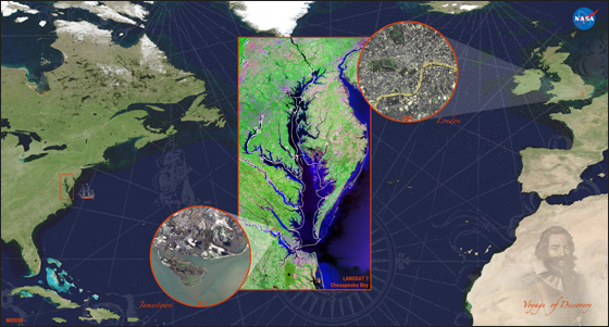
Landsat Image Presented to Queen Elizabeth II
In a historical event for NASA’s Goddard Space Flight Center, Queen Elizabeth II of England visited the NASA campus on May 8, 2007. One of the many diplomatic gifts presented to the Queen was a poster commemorating John Smith’s voyage of discovery in 1607 using data from Landsat 7, MODIS, and EO-1.
Landsat at the Biennial George Wright Society Conference
Rethinking Protected Areas in a Changing World • April 16-20, 2007, St. Paul, MN The George Wright Society (GWS) is a nonprofit association of researchers, managers, administrators, educators, and other professionals
Landsat Education Specialist at the AAG meeting
The NASA Landsat project sent an education/outreach specialist, Jeannie Allen, SSAI, to the Association of American Geographers annual meeting on April 17 to give a presentation on “Integrating Remote Sensing
USGS Landsat Newsletter Published
The USGS Landsat Newsletter (vol. 1, issue 1, 2007) has been published on the USGS Landsat website. Its content includes: Landsat Science Team Meeting held January 9-11, 2007 Landsat in Everyday Places
Rainforest Monitoring Improved by Data Fusion
In late April, Science magazine reported that Brazil is a world leader in tropical forest monitoring thanks to their use of data from a number of Earth-observing satellites. Brazil’s Instituto
LTWG-16 Meeting Held in Brazil
Contributor: Terry Arvidson The 16th Landsat Technical Working Group (LTWG) meeting was held in Brazil May 14-18, 2007. The meeting was organized by USGS and hosted by the Instituto Nacional
NASA Awards LDCM Accommodation Study
NASA Goddard Space Flight Center’s Rapid Spacecraft Development Office (RSDO) awarded delivery orders to four contractors for the Landsat Data Continuity Mission (LDCM) Spacecraft Accommodation Study on April 30. “The
"The Planet NASA Needs to Explore"
An editorial in today’s Washington Post warns that NASA’s budgetary shift away from Earth science priorities is perilous for our understanding of global warming and its impacts. The piece, authored
Forest Trends in Madagascar
A recently released study provides evidence that social dictums influence the stability of tropical dry forests more than proximate population density. Often, it is assumed that a rising local population
Landsat Image Presented to Queen Elizabeth II
In a historical event for NASA’s Goddard Space Flight Center, Queen Elizabeth II of England visited the NASA campus on May 8, 2007. One of the many diplomatic gifts presented to the Queen was a poster commemorating John Smith’s voyage of discovery in 1607 using data from Landsat 7, MODIS, and EO-1.
Landsat at the Biennial George Wright Society Conference
Rethinking Protected Areas in a Changing World • April 16-20, 2007, St. Paul, MN The George Wright Society (GWS) is a nonprofit association of researchers, managers, administrators, educators, and other professionals
Landsat Education Specialist at the AAG meeting
The NASA Landsat project sent an education/outreach specialist, Jeannie Allen, SSAI, to the Association of American Geographers annual meeting on April 17 to give a presentation on “Integrating Remote Sensing
