
[NASA Ames Research Center] NASA, in collaboration with the United States Department of Agriculture (USDA), United States Geological Survey (USGS), and the California Department of Water Resources, released data today showing the effect the current drought has had on agricultural production and the idling of California farmlands.
The datasets map the change in idle, or fallowed, lands — agricultural acreage typically cultivated but allowed to lie idle during one or more growing seasons — across the California Central Valley over the past five years. The datasets highlight increases in idle farmland in the Central Valley as the drought has extended into its fourth year.
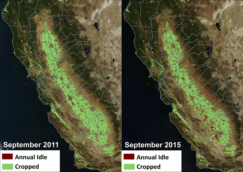
NASA and USDA estimate that more than 1.03 million acres have been idle all year, which represents approximately 15 percent of the 7 million acres of irrigated farmland in California’s Central Valley. This is more than double the amount of idle agricultural acreage in 2011, which was the last calendar year following a winter with average or above average precipitation across the state.
“As the summer season starts to wind down and the 2015 California water year comes to an end, the data illustrates the toll the drought has taken on California agriculture,” said Forrest Melton, senior research scientist at NASA’s Ames Research Center in Moffett Field, California.
The datasets were produced as part of a joint project to use satellite data to continuously track changes in unplanted agricultural acreage during the drought. Results for 2015 indicate that the extent of unplanted agricultural land increased in the Central Valley by more than 500,000 acres in winter and summer months relative to 2011. The project represents the first time state agencies used satellite data to track drought impacts on agricultural lands in California.
Additional analyses conducted by NASA separated estimates of idle acreage for the winter and summer seasons in the Central Valley. This analysis revealed that during the summer season, when many high value crops are produced and harvested, a total of 1.92 million acres of farmland have been left idle since June 1. This represented an increase of 522,000 acres since 2011, when only 1.39 million acres were left unplanted during the entire summer growing season. NASA’s data confirms the model-based estimates included in a report on economic impacts of the drought released by UC Davis in August, which estimated 540,000 acres were fallowed in 2015 due to the drought. In 2015, the largest increases in idle acreage were observed along the west side of the San Joaquin Valley in Fresno, Kings and Kern counties.
The datasets on land fallowing were derived using thousands of observations collected by multiple satellites over California including Landsat, a joint NASA and USGS mission, as well as NASA’s Terra and Aqua satellites. The satellite datasets were processed and analyzed by scientists at Ames and the USDA National Agricultural Statistics Service, who created time series of monthly field conditions for every field in the state. The team used the data to create monthly reports for the California Department of Water Resources.
At Ames, the computing-intensive analysis of these satellite scenes was conducted using the NASA Earth Exchange (NEX), a research platform that allows scientists to perform analyses of Earth observation data using the state-of-the-art computing resources of the NASA Advanced Supercomputing Facility.
“These datasets highlight the continuing impacts of the drought on agricultural communities in California, and identify regions in the state that have been particularly hard hit by water shortages,” said Melton. “At the same time, the data provide insights into regions of the state that have been more resilient to the drought and that have been able to sustain agricultural production despite the reductions in surface water supplies.”
The datasets were produced as part of a collaborative effort conducted as a pilot project for the National Oceanic and Atmospheric Administration’s (NOAA) National Integrated Drought Information System (NIDIS) for California.
California’s 2014 drought emergency proclamation directed the state’s Department of Water Resources to monitor agricultural land fallowing to better quantify drought impacts. “This remote-sensing application gives us a unique opportunity to see impacts in near real-time during the growing season, over a widespread geographic area,” said Jeanine Jones, interstate resources manager for DWR. “Previously, we had to wait until the following year to see the USDA NASS cropping data tabulation.”
NASA uses the vantage point of space to increase understanding of our home planet, improve lives, and safeguard our future. The agency develops new ways to observe and study Earth’s interconnected natural systems with long-term data records, freely sharing this unique knowledge while working with institutions around the world to gain new insights into how our planet is changing.
This project was initiated in response to a request from the California Department of Water Resources for assistance in improving estimates of land fallowing during drought events. With support from the NASA Applied Sciences Program, NOAA/NIDIS, USGS and USDA, the multi-agency team has been working together to advance monitoring and mapping of drought impacts on agricultural lands in near real-time. The project team also included scientists and students from California State University Monterey Bay who collected ground observations in hundreds of agricultural fields across California to verify the accuracy of the satellite maps.
Additional information about the NASA estimates of fallowed agricultural lands, including links to download the data and report, is available at: https://nex.nasa.gov/nex/projects/1372/


