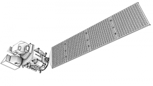
Now available to the public, the compendium of 23 published papers describes how Landsat 8 is the most capable of the seven operational Landsat missions and highlights how Landsat 8’s enhanced performance and new capabilities enable better science and research results. The selected articles cover topics from how the instrument’s performance gives higher quality electromagnetic measurements to how its improved geometry allows for the tracking of moving ice sheets.
More data, better data, expanded applications
“I would summarize Landsat 8’s science impacts in three ways,” said Tom Loveland, Chief Scientist at the U.S. Geological Survey Earth Resources Observation and Science (USGS EROS) Center in Sioux Falls, S.D. “More data, better data, and improved, expanded applications. The papers in the special issue explain how the specific capabilities now available on Landsat 8 enable us to do things better.”
Loveland and James Irons, Deputy Director, Earth Sciences Division, NASA, served as the guest editors for the special issue.
Launched on Feb. 11, 2013, Landsat 8 is a joint USGS-NASA endeavor that continues the legacy of continuous, moderate-resolution observations started in 1972. The mandate of the Landsat program is to help detect and characterize global land change at a scale that enables differentiation between natural and human-induced causes.
Journal citation
Remote Sensing of Environment
Landsat 8 Science Results
Edited by Thomas R. Loveland and James R. Irons
Volume 185, Pages 1-284 (November 2016)

