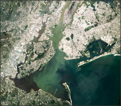
On August 31, 2011 Landsat 5 orbited over the U.S. Eastern seaboard capturing imagery of regions affected by Hurricane Irene from New York to the Carolinas. Irene’s heavy rains caused sediment-laden run-off to enter the streams and rivers in her path. The rivers then dumped their sediment-heavy water into bays and sounds that then carried the sediments into the Atlantic. The long swath of Landsat 5 imagery shows sediment plumes in Delaware Bay, Ablemarle Sound, and along the Maryland, Virginia, and North Carolina coasts. Many regional rivers are brown with sediments, especially New York’s Hudson River. The huge tract of land imaged by Landsat 5 has been mosaicked and posted on GigaPan by Earth Observatory’s Robert Simmon.
See more:
+ Mosaic of Landsat 5 swath over the Eastern seaboard [external link]
+ Sediments seen in New York Harbor post-Irene, NASA Earth Observatory

Landsat & LCLUC: Science Meeting Highlights
Outreach specialists from the Landsat Communications and Public Engagement team participated in community engagement efforts at the joint NASA and University of Maryland Land Cover Land Use Change (LCLUC) meeting.


