This compendium was put together to foster a more complete understanding of available resources for global land cover information, because Earth observing satellites are uniquely situated to, as the author’s write, “map, measure and monitor how, when and where land resources are changing across the globe.”
The reason we need to be knowledgeable about land cover, is explained by the authors in this way:
“Land cover information is important because the land is where most of the seven-plus billion humans live most of the time. It meets the major part of our food, fuel, freshwater and fiber requirements and shapes our planet’s climate system. The land is itself under pressure from climate change and from degradation processes such as desertification. A growing and shifting human population too changes and moves pressures on the land. As land is essentially a finite resource this leads to intense competition between land used to produce different food types, land for cash crops, sources of fiber, biofuels/bioenergy and for ever-increasing urbanization. In recent years this competition has extended to include new dimensions such as carbon trading and biodiversity offsetting. Our land-use marketplace now not only has to satisfy our fundamental resource requirements such as food and energy production, but it must also maintain and enhance land’s role as a carbon sink and a support for biological diversity.
“Decision makers and policy makers at national and international scales aim to find a balance between competing demands on the land resource. These policy goals usually aspire to keeping land resource use in balance with regenerative capacity. Land-use management plans stand the best chance of success if they are based on sound information concerning how, when and where land resources are being used and how this is changing.”
Belward and Skøien looked at all satellites launched between Oct. 4, 1957 (i.e. the first ever satellite launch) and Dec. 31, 2013. They then focused on the 879 satellites that contributed to Earth science, and further narrowed their search to the 197 missions that could be used for global land cover mapping based on their criteria of (1) a near-polar orbit, (2) data available for civilian use, and (3) carrying an imaging device. While the ability to image anywhere on the globe (with the exception of the poles) was one of the criteria, the ability to provide exhaustive wall-to-wall global imagery was not.
Landsat 1, launched on July 23, 1972 was the first mission that could be considered a global land cover mapping satellite. The authors used the date of Aug. 1, 1972 as a starting reference point to evaluate the number active land cover mapping satellites in use each decade. On the first date, Aug. 1, 1972, Landsat 1 was the lone satellite. One decade later, there were eight satellites, two decades later there were 20, three decades later there were 39, and four decades later there were 83 such satellites in operation. Of the 197 satellites the authors identified, nearly half were still operational as 2013 came to a close.
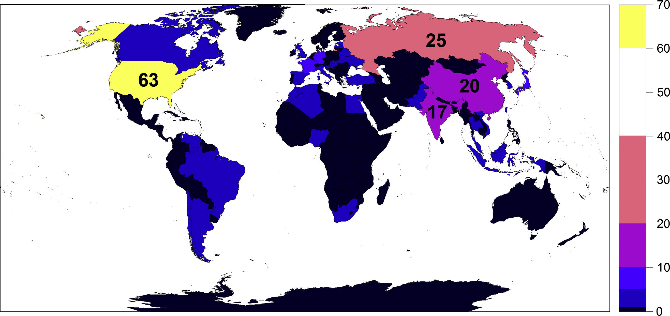
Each decade more countries have invested in Earth-observing satellites so they can monitor how land resources are changing.
While authors are encouraged by the increasing robustness of relatively inexpensive small cubesats to acquire meaningful information about the planet’s land cover, there are hallmarks of the Landsat program that they contend must be carried forward. Namely:
(1) Continuity—a reliable data supply is essential for national and international treaties that rely on satellite information for their decision making process. Continuity also allows researchers to build familiarity with the data and better their analysis approach.
(2) No cost data—open archives encourages new science and applications and enables global wall-to-wall studies.
(3) Calibration—land cover change measurements are more meaningful when cross-calibrated data are used to ensure that measured changes are true physical differences, not data anomalies.
The authors, state:
“The success of a mission, at least in terms of its use for land cover work, does not just depend on successful design, build, launch and flight operations but also on its data acquisition strategy, its capacity for archiving, cataloguing, caring for data, its data access policy, and its ability to make the data easy to find and easy to physically obtain. Restrictive data policies and convoluted data access systems should be avoided. The trend to full free and open data access is on the rise, even for higher resolution data. Landsat paved the way and others are following.”
In their conclusion the authors, maintain:
“Satellite launches are no longer rare. The view of Earth from space now verges on the mundane. Thanks to Google Earth and Bing these views are a near every-day experience for countless people. But there is a risk in such familiarity. It becomes easy to take global land cover observations for granted, which should not happen. Securing the continuity of programs such as Landsat, SPOT, NOAA, CBERS, IRS, JERS, Resurs, DMC and others requires vision, dedicated and talented scientists, engineers and mission operators as well as funds.”
Reference: