
Major disasters can temporarily make existing maps obsolete, rewriting river boundaries, shorelines, and land features in an instant. When disasters strike and first responders need to understand new situations on the ground, the best source of information often comes from the sky. Satellites, like Landsat, can tell responders what damage disasters have done, providing timely insight into flood extents, fire boundaries, lava flow directions, road traversability, and oil slick movements.
Taking Action
In 1999, at the Third United Nations Conference on the Exploration and Peaceful Use of Outer Space (UNISPACE III) in Vienna, the European Space Agency (ESA) and the French space agency (CNES) proposed a system to supply free satellite imagery to emergency responders anywhere in the world. The outcome was the creation of the International Charter Space and Major Disasters; “Charter” for short.
The Charter concept is this: a single phone number is made available to authorized parties providing 24/7 contact to a person who can activate the charter. Once activated, a project manager takes charge. The project manager knows what satellite resources are available, how to task them to collect data, and how to quickly analyze the collected data to create impact maps for first responders. These maps, provided to responders for free, often show where the damage is and where crisis victims are, allowing responders to plan and execute relief support.
You can think of the Charter as a one-stop-shop for impact maps—an essential resource, since in many cases satellite data are the only practical method to assess current ground conditions after a disaster.
Today, 15 space agencies and more than 30 satellites are part of the Charter, pooling their combined resources to ensure that spacefaring nations can quickly share their data for a humanitarian undertaking. Since its inception, the Charter has been activated more than 400 times.
U.S. Participation
While the U.S. was not originally part of the Charter, the National Oceanographic and Atmospheric Administration—with its mighty fleet of meteorological satellites—soon became a member in 2001. The U.S. Earth-observing satellite fleet, including Landsat, was not officially part of the Charter until the U.S. Geological Survey joined in 2005.
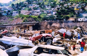
Landsat was used during the very first charter activation. That first call came in November 2000 after a large landslide in Slovenia. After weeks of torrential rainfall, a small landside dammed up the Mangart Stream near the Italian border. The resulting pooled waters worked in tandem with the saturated slopes of Slovenia’s Mount Mangart to cause the mountainside to give way overnight. An estimated 1 million cubic meters (35 million cubic feet) of debris flowed into the Soca River, devastating a small village and killing seven people en route.
The Charter was activated a few days later. Thirteen satellite images were used, including two Landsat images taken before the disaster. All of the satellite images were gathered into a geographic information system (GIS) where the damage was analyzed. Using Landsat and SPOT imagery, a land use map was quickly created. This helped data analysts show responders that, although the majority of damage occurred in areas covered by deciduous forest, there was also significant damage in agricultural and inhabited areas.
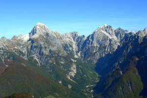
In July 2001, the first volcano Charter activation was requested by the Italian Civil Protection Agency for an eruption of Sicily’s Mount Etna. Again Landsat and SPOT images were processed along with radar images. The Landsat thermal bands were used to map thermal anomalies before and after the July 26 eruption. These maps helped authorities forecast lava flows threatening human populations on the mountain slopes and to determine risks of new vents.
In 2004, at the onset of the rainy season in August, the Charter was activated to aid a flood-caused refugee situation in western Sudan. Humanitarian relief organizations there found themselves in urgent need of current detailed maps. The Disaster Charter used satellite resources to map regions around the cities of Al Fashir and Al Junaynah to ascertain road networks and conditions and to find out what was traversable in the flood conditions. Landsat, SPOT, and ENVISAT-ASAR (radar) satellite imagery were used to accomplish this.
Then in late 2004, a magnitude 9 earthquake triggered a devastating tsunami that affected Sumatra, Thailand, Sri Lanka, and southern India, killing more than 200,000 people. The Charter was activated three times to cover the large expanse of damage. Both medium resolution data (Landsat, SPOT, Disaster Monitoring Constellation) and very high-resolution data (IKONOS, Quickbird) were used to map impacted areas and to calculate damage extent. This gave first responders an overview of the situation on the ground and provided them with information needed to plan relief logistics.
The U.S. Earth-Observation Fleet Joins the Charter
After the staggering devastation wrought by the Indian Ocean tsunami, Brenda Jones, a Disaster Response Coordinator with the U.S. Geological Survey (USGS) got an email from Charley Hickman, a USGS State liaison in Ohio. Hickman wanted to know why Landsat was not officially part of the Charter. Jones looked into the matter and quickly discovered that the Charter was keen to partner with USGS.
“The Charter was very interested in having USGS join because of Landsat,” Jones recounts.
Thus, in early 2005, USGS became an official participating agency of the Charter. While USGS had joined because of its Landsat resources, USGS membership brought a suite of other valuable satellite data to the Charter, including NASA’s MODIS, ASTER, EO-1—and even photos taken from the International Space Station. Additionally, commercial high-resolution vendors contribute their data through USGS.

“Medium resolution satellites… proved to be more advantageous over the very high-resolution IKONOS data, which were used only for the affected urban areas,” analysts later wrote.
Landsat’s combination of spatial and spectral resolution together with its 186-km (115-mile) image width makes its data particularly useful after hurricanes, fires, and volcanoes, and floods.
“It is very good for getting an overall extent of the disaster. It’s been very useful for the Charter,” Jones shared.
“Really, that’s one of the main reasons we are involved—to do the tasking,”
Jones said.
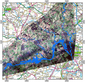
This January, Landsat data were used when the Thames River flooded. A Landsat 8 image acquired on Jan. 7, 2014, was provided to the United Kingdom’s Environment Agency through the Charter. Kyle Brown, a Senior Geomatics Analyst with the agency, was the Charter project manager for the call. Brown and his team did some of the image analysis and mapping and were able to derive flood outlines for a section of the Thames using Landsat imagery.
“The flood outline data were used at a local and national level to provide a strategic overview of the flooding and to help prioritize resources,” Brown explained.
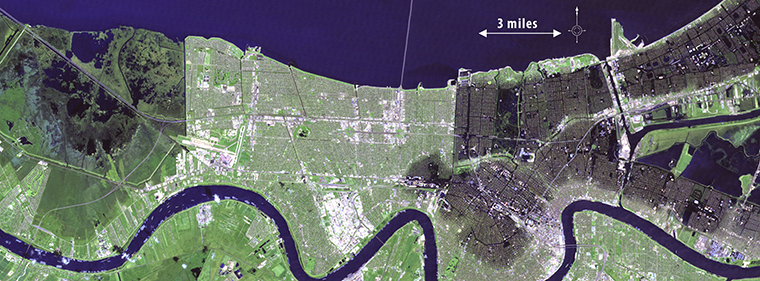
Domestically, since USGS joined the Charter, Landsat data have been used to aid in damage assessments after Hurricanes Katrina and Rita ravaged the Gulf coast—monitoring receding flood waters. Landsat imagery has also been used to map fire extents in the West, to map severe flooding in the mid-west, and to map the Gulf oil spill.
Although Landsat has been an important resource since the Charter began, its use has increased with USGS participation.
“Since 2005, when USGS became a member, we have provided data for 149 activations,” Jones reports.
The Charter makes Landsat one more tool in a shared toolbox of space-based resources that can be used to provide first responders with the maps they need to help save lives around the world.
Further Reading
+ The Charter in Action [videos]
+ Landsat Tracks Urban Change and Flood Risk
+ After a Fire, Before a Flood: NASA’s Landsat Directs Restoration to At-Risk Areas


