This group award recognizes a team that has made major breakthroughs in remote sensing science or technology that impact the user community.
The Landsat 8 Team—including members from NASA, USGS, and the aerospace industry—is being recognized for its role in developing, building, launching, and operating the highly successful Landsat 8 satellite. Landsat 8 carries on the more than four decade Landsat data record using advanced new sensors. Its data collections contribute towards our evolving understanding of Earth’s land surface and coastal regions.
As Dr. Forrest Hall, a Senior Research Scientist at the University of Maryland—Baltimore County’s Joint Center for Earth Systems Technology, wrote in his letter of support for the Landsat 8 team nomination:
“Landsat 8 represents yet another substantial advance to continuing a 40 year land data record, essential to understanding the Earth’s biosphere, anthropogenic changes to land use and land cover, the terrestrial carbon cycle, and the consequences for climate and biodiversity. This important extension to the Landsat series, the Landsat 8 mission, was achieved, through an outstanding interagency and industrial partnership, effectively managed to achieve breakthrough improvements in satellite and sensor performance.”
Dr. Susan Moran, a Research Hydrologist with the U.S. Department of Agriculture and nomination supporter, wrote:
“What makes this mission team special is the fervor they brought to task. They were challenged to retain the historic data continuity, yet take advantage of new technology while balancing cost and complexity. Few, if any, missions face such a challenge with such consequences on the line. After more than a decade of dedication, this Team launched a new sensor that was more sensitive and robust than previous sensors, and provided not only data continuity but even more and better data.”
And Dr. Alan Strahler, a Professor of Earth and Environment at Boston University and another nomination supporter, wrote:
“What a Landsat it is! The data are strikingly good and the delivery system is flawless. Landsat 8 arrives just as Landsat data use has exploded under the free data policy and the ability to deliver geolocated and atmospherically-corrected products… new and exciting applications are being revealed daily.”
The 2014 individual Pecora Award was presented to Christopher Justice. Dr. Justice, a leading remote sensing scientist, has served as a remote sensing advisor, educator, and research director. His work has advanced the field of remote sensing science while influencing and encouraging many of the field’s current innovators.
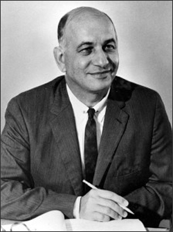
The William T. Pecora Award was established in 1974 to honor Pecora. Sponsored jointly by the Department of the Interior and NASA, it is presented annually to individuals or groups that make outstanding contributions toward understanding the Earth by means of remote sensing.
Further reading:
+ USGS-NASA Award Recognizes Innovations in Earth Observation (USGS)
+ NASA-USGS Award Recognizes Innovations in Land Observations (NASA)
+ NASA and USGS Recognize Landsat 8 Satellite Team for Innovations in Earth Observations (Orbital press release)
+ Ball Aerospace Honored by NASA and U.S. Department of Interior with Pecora Award for OLI Imaging Instrument Aboard Landsat 8 (Ball Aerospace)
+ William T. Pecora, Pioneer of Earth Science from Space

Be Part of What’s Next: Emerging Applications of Landsat at AGU24
Anyone making innovative use of Landsat data to meet societal needs today and during coming decades is encouraged to submit and abstract for the upcoming “Emerging Science Applications of Landsat” session at AGU24.


