
Through this collaboration, Leigh and his team of three graduate students have direct access to the Google archives that include EROS images and the computing power to compile the images via Google Earth Engine and its cloud computing capabilities.
The primary project goal was to identify pseudo-invariant calibration sites or PICS. These are remote places, such as deserts and dry lake beds —where the surface properties and therefore the reflectance, do not change over time.
PICS provide a less expensive means of calibrating satellites because it eliminates the need to gather measurements on the ground when the satellite is passing overhead.
“When a satellite observes these test sites, it should measure the same amount of energy each time,” explained Dennis Helder, director of the SDSU Image Processing Laboratory. “You don’t have to put a team in the field at the site or do a lot of data processing from the field team’s measurements,” he pointed out.
After these new sites are thoroughly characterized, Leigh said, “they can be used as routine calibration sites, thus increasing our frequency of observation and improving our ability to detect calibration drift in a much shorter time period.”
Most satellites are calibrated on a somewhat irregular basis; however, the discovery of more sites may make daily calibration possible, he noted.
Using nine spectral bands from Landsat 8, the team produced what Leigh called “our first-ever PICs global survey.” The global image, degraded to a 300-meter resolution, took nearly 350 hours to produce.
“This output is being analyzed to generate a whole new list of PICs,” he added. However, he noted, Landsat 8 has only been in orbit a little over three years.
The next step will be to run the Landsat 5 archive, which contains nearly 30 years of data—from March 1984 until June 2013. This will allow the researchers to evaluate the longevity of these new PICs and possibly use these sites to calibrate data from past Landsat missions.
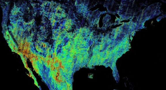
To identify PICS in the United States, Leigh and his team have produced a composite image containing 60,000 Landsat 8 images from July 2013 to December 2015. It took a portion of a 1000-node cluster at Google approximately nine hours to compile the U.S. image at a degraded 900-meter, rather than the full 30-meter, pixel resolution.

Be Part of What’s Next: Emerging Applications of Landsat at AGU24
Anyone making innovative use of Landsat data to meet societal needs today and during coming decades is encouraged to submit and abstract for the upcoming “Emerging Science Applications of Landsat” session at AGU24.


