Search
Close this search box.

A Look at National Land Cover Database 2011

A Look at National Land Cover Database 2011

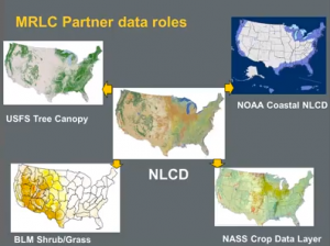
NLCD partner contributions [Source: USGS via YouTube] This 40-minute video presentation by Dr. Collin Homer, from the USGS Earth Resources Observation and Science Center (EROS), gives an overview of the latest version of the National Land Cover Database—NLCD 2011—its current status, future plans, and applications examples. The data in NLCD 2011 are completely integrated with those of previous versions. Fourteen product suites now harmonize and integrate land cover change across the conterminous United States through 2001, 2006, and 2011. NLCD is derived from Landsat data. There are three-flagship products: Land Cover, Canopy Cover, and Imperviousness. (This is a lot of data, as the NLCD team says, “30-billion pixels served.”)
Further Information:
+ Multi-Resolution Land Characteristics Consortium

On Key

Recent Posts

On Key

Related Posts