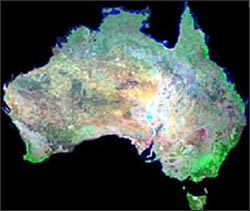
Landsat data are being used to study decadal trends in vegetation around the globe to support modeling of carbon fluxes to the atmosphere. Australia’s Greenhouse Office has pioneered this effort, assembling a 30-year record of forest-cover changes from some 3000 individual Landsat scenes. These observed changes in forest area can then be converted to changes in biomass (carbon) using models that predict the growth of individual forest stands. This work supports the Australia National Carbon Accounting System (NCAS), which is verifying compliance with the Kyoto Protocol.
Although the United States is not a signatory to the Kyoto treaty, the North American Carbon Program (NACP) partnered government agencies and academic institutions to intensively study the sources and sinks of carbon within the North American continent, and understand how those fluxes may change in the near future. Land-cover change information derived from Landsat and other NASA satellites are an important part of NACP science.
Contributor: Jeff Masek

Be Part of What’s Next: Emerging Applications of Landsat at AGU24
Anyone making innovative use of Landsat data to meet societal needs today and during coming decades is encouraged to submit and abstract for the upcoming “Emerging Science Applications of Landsat” session at AGU24.


