
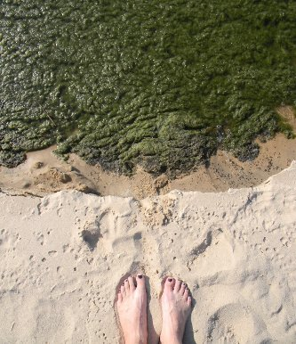
Bob Shuchman, the co-director of the institute, and his colleagues including senior research scientist Colin Brooks and Michigan Tech professor Marty Auer, started using Landsat data for lakebed analysis in 2009. As part of a NASA-funded feasibility study, they developed computer programs to analyze color gradations in satellite data and turn it into a map of submerged aquatic vegetation, primarily Cladophora, near the Sleeping Bear Dunes National Lakeshore in Michigan. Once they developed the program, the U.S. Environmental Protection Agency asked them to map coastal waters of four of the Great Lakes.
The maps were useful not only for water quality researchers and regulators, Shuchman said, but the beach-going public as well. “You don’t want to take the grandkids to a place where they’re going to get muckety muck all over their feet,” he said.
The team began with the remote sensing satellite data from Landsats 5 and 7. Then they went back to the first Landsat image they could find – in 1974, from Landsat 1, then called the Earth Resources Technology Satellite. From there, they looked at the distribution of Chladophora algae every five years.
“Landsat was really a time machine for us,” Shuchman said. “The team used it to go and study selected areas in the Great Lakes to fill in the times when the scientists weren’t studying it.”
With Landsat 8, the researchers can continue that time series. They’ve used the satellite to look at the algae extent around Sleeping Bear again. Shuchman said the new data allows them to determine the algae’s density, and also see through deeper waters – which expands the area they can search for green.
“We can tease out more information about what’s on the lake bottom,” he said. “Landsat 8 gives us continuity, but it also lets us do a better mapping job.”
Sediment swirls and chlorophyll whirls
Landsat 8’s more detailed aquatic observations don’t stop at algae. Researchers in Belgium are looking at the swirls of sediments created by wind turbines in near shore waters. Wind companies are required to monitor the environmental impact of the turbines, explained Quinten Vanhellemont, a scientist with the Royal Belgian Institute for Natural Sciences, and Landsat has the spatial resolution—and the sensitivity—to pick up some of the smaller features.
“The resolution and sensitivity of the imager on board makes it an ideal sensor for coastal water applications. On almost every image we process there are interesting features, some we had never considered before,” Vanhellemont wrote.
At NASA’s Goddard Space Flight Center in Greenbelt, Maryland, scientists in the Ocean Ecology Laboratory are looking to Landsat 8 as well. They have created open-source software that researchers use to analyze satellite data for studies on marine phytoplankton chlorophyll concentration other water constituents.
Currently they use satellites that take the big view, but Bryan Franz, a research oceanographer at Goddard, worked with Vanhellemont to see how well Landsat 8 data could be processed to determine chlorophyll patterns in coastal waters. It shows promise, Franz said. He plans to add Landsat 8 data to the software this summer to see how the ocean research community will use it.
“There are plenty of coastal ecosystem managers and people out there that have interest,” Franz said. “They’ll use these tools if we make them available … the community will run with it.”
Further information:
+ Taking NASA-USGS’s Landsat 8 to the Beach
+ Using Landsat to Map Cladophora in the Great Lakes
+ Return of the Slime
+ NASA Goddard’s Ocean Ecology Lab


