Search
Close this search box.

Beautiful New Landsat Mosaic of Chesapeake Bay

Beautiful New Landsat Mosaic of Chesapeake Bay

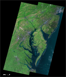
Chesapeake Bay mosaic
The new Chesapeake Bay mosaic release by USGS.

USGS has released a new mosaic of the Chesapeake Bay. Using six Landsat 5 images collected in July 2009 and 2011 a beautiful, seamless mosaic of the Chesapeake Bay region was created by the USGS Landsat team. The Washington D.C.-Baltimore-Philadelphia-New York City corridor can be clearly seen (look for silvery purple) as can the Chesapeake and Delaware Bays and the coastal Atlantic barrier islands from Fishermans Island, Virginia to Sandy Hook, New Jersey.
Download:
+ High resolution Chesapeake Bay mosaic

On Key

Recent Posts

Earthrise

Remembering Bill Anders

Anders, 90, the astronaut who captured the iconic Earthrise photograph, died on June 7, 2024, when the plane he was piloting crashed into the San Juan Channel.

Read More »
On Key

Related Posts