
By: Mike Wulder, Senior Research Scientist with the Canadian Forest Service
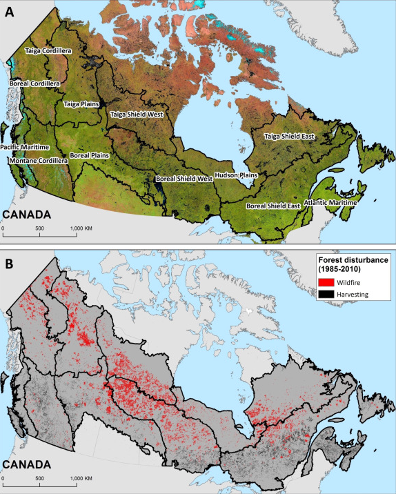
(B) Map of the area disturbed by wildfire and harvest (1985–2010), as identified using the Composite to Change (C2C) approach.
Image credit: White et al., 2017
“The capacity to distinguish recovery trends by disturbance type provides insights on forest dynamics that are both spatially detailed and national in scope.”
What are the major findings of this research?
- 57.5 Mha or 10.75% of Canada’s net forested ecosystems (exclusive of water) were disturbed by either wildfire or harvest, representing an annual rate of disturbance of approximately 0.43% per year.
- Wildfire accounted for 2.5 times more area disturbed than harvest. On average, wildfire impacted 1.5 Mha annually, compared to 0.65 Mha impacted by harvesting. Moreover, the amount of area impacted by wildfire was much more variable annually (σ = 1.5 Mha) when compared to harvest (σ= 0.1 Mha).
- Regionally, boreal ecozones had the greatest absolute area of disturbance from both wildfire (Boreal Shield West) and harvest (Boreal Shield East).
- Spectral recovery metrics indicate that vegetation returns following disturbance.
- Areas impacted by harvest exhibited more rapid spectral recovery rates.
- 78.6% of areas impacted by harvest having a mean recovery time ≤ 10 years, compared to 35.5% of areas impacted by wildfire
- Overall, less than 1% of the areas disturbed by wildfire and harvest were identified as non-recovering by all three spectral measures of recovery used in our analysis.
Citation and open access:


