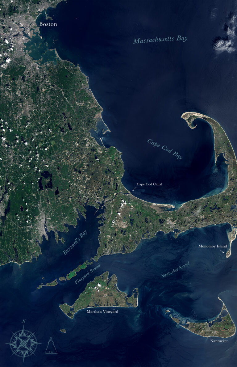
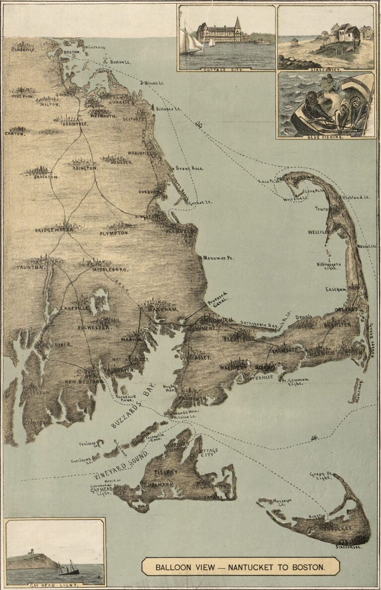
The sandy peninsula of Cape Cod, Massachusetts juts into the Atlantic Ocean with its characteristic crook and twirl in both images: “Balloon View–Nantucket to Boston” made in 1885, and a Landsat 8 satellite image made 129 years later in 2014. Aspirations to rise above the Earth and to record the Earth’s surface from there are a long-standing theme of human culture. Animals helped humans to test flight in a balloon, according to this appealing account of an unusual bit of history from 1783: “The caged duck looked down as terra firma slowly drifted away. Above the duck, a balloon, constructed of paper and fabric, provided the lift necessary to carry aloft the duck and its companions, a sheep and a rooster.” The balloon apparently stayed in the air for 15 minutes before crashing back to the ground, hopefully not too jolting an experience for the animals, and certainly giving hope to people who wanted a safe balloon ride. Just a few months later, the Frenchman Jean-François Pilâtre De Rozier achieved his dream of the first untethered manned balloon flight, to an altitude of 500 feet and a distance of five and a half miles. He descended safely. Such ballooning events of that time began a new technological era, one that has lead to more milestones in viewing and recording Earth from space.
Photography, ballooning and remote sensing technologies are tied together. The technology of modern remote sensing began with the invention of the camera more than 150 years ago. Frenchman Felix Nadar took the first aerial photographs from a balloon in the 1860’s. Nadar’s photographs may have been known to the creator of “Balloon View,” who may have used similar photographs taken from a camera mounted on a balloon, or who may have ascended by balloon for a lofty view of the Cape in person to achieve the aerial perspective required by the artwork.
Animals continued to play a part in the progress of remote sensing, as pigeons helped to promote photography from the air. They were used for aerial reconnaissance during the First World War, although by then cameras were also mounted on airplanes. From then until the early 1960s, plane-based aerial photography was a standard tool for depicting the surface from a vertical or oblique perspective. Weather satellites began observing the Earth in the 1960s. Since the early 1970’s, engineers have fulfilled our high-altitude Earth viewing aspirations with marvelous space-based technology that includes our Earth-orbiting satellites. With instruments on Landsat people record Earth’s changing landscapes from 705 km above the planet’s surface on a routine basis with high precision and consistency every day.
Comparing the Landsat image of 2014 with the Balloon View image of 1885, one notices not only differences in color but also differences in what is featured, reflecting both the economic life of the Cape in 1885 and the different technologies of those times. The 1885 artist limits colors used to browns and grays in order to focus on the topic of transportation, while Landsat automatically captures the reflected greens, blues and browns of the land and sea, a colorful aspect of contemporary remote sensing technology.
The 1885 image focuses on roads and on shipping lanes, indicated by dotted lines, because shipping, fishing, and whaling were important here until the late 1800s. The 1885 image includes a label for a proposed canal across the neck of land between the Cape and the mainland connecting Buzzard’s Bay to Cape Cod Bay. The canal was to make an important waterway for north- or south-headed sea-goers and their vessels to protect them from ravages of ocean storms along the outer edges of the Cape. The canal had long been constructed by the time of Landsat’s record in the early 21st century. (See label on Landsat scene.)
By Landsat’s time, the endeavors of fishermen and oystermen, farmers and salvagers, lighthouse-keepers and ship captains have long given way to jobs that support water- and beach-based tourism. Combining tourism and retirement totals nearly two-thirds of the Cape Cod economy. In the 2014 Landsat image, the prominent zigzag shaped line toward the left shows a highway that brings tourists to the far edges of the Cape, discernable because straight lines and right angles rarely appear in purely natural landscapes. Tiny rectangular gray-brown features in the Landsat image are giveaways that people have covered the landscape with buildings as well as with roads. Beaches make bright outlines around much of the Cape, and kettle ponds appear as dark shapes throughout the Cape. Those natural features were ignored by the artist in 1885, whose attention was focused more on fisheries than on nature herself. Landsat sees into the ocean waters to some depth, revealing swirling current-shaped sediments, while the 1885 artist does not represent such currents at all.
Shoreline changes between 1885 and 2014 can be seen particularly easily in the southeastern portion of the Cape. Monomoy Island, in 2014 is a long teardrop-shaped island south of the Cape whereas in 1885 it was a long thin island without the teardrop-shaped southern point. To see such features from above, one can still take a hot air balloon ride over Cape Cod.
+ download large 1885 map
+ download large Landsat 8 mosaic image
References
“Balloon View, Nantucket to Boston.” Library of Congress. Visited 26 May 2014
NASA Earth Observatory. “Remote Sensing: Introduction and History.” Visited 26 May 2014
NASA Earth Observatory, World of Change, “Coastline Change.” Visited 26 May 2014
NASA Visible Earth, “Cape Cod National Seashore.” Visited 16 January 2015
U.S. Geological Survey. “Geological History of Cape Cod, Massachusetts.” Visited 21 January 2015
U.S. National Park Service. “Cape Cod National Seashore: Its History and Culture.” Visited 21 January 2015
Image created using Landsat 8 OLI bands 4,3,1 The image was collected June 1, 2013. Image by Mike Taylor using Landsat data available from the USGS archive. Caption by Jeannette Allen