
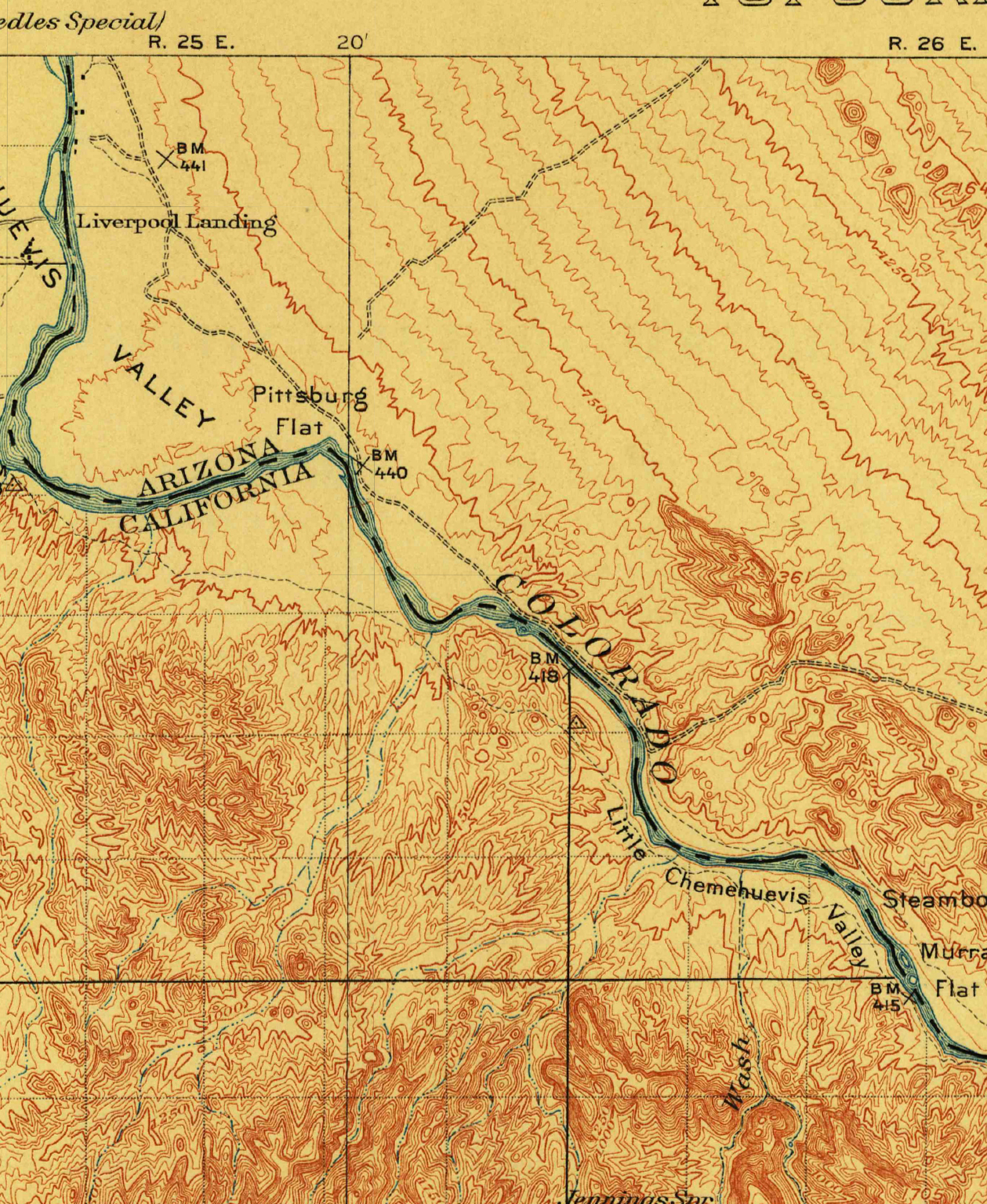
Parker Dam was constructed on the California-Arizona border on the lower Colorado River during the 1930s, as part of a project to employ people during the Great Depression, to generate electricity, and to provide water that could be pumped into aqueducts for agricultural, industrial, and residential use in other parts of Arizona.
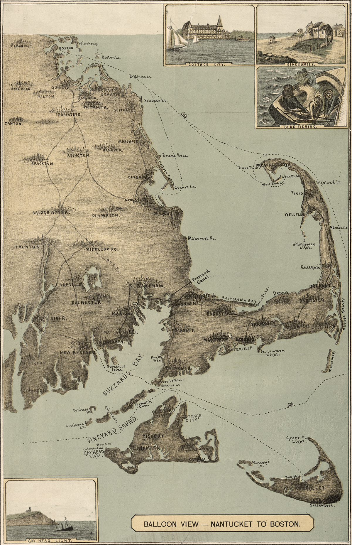
The sandy peninsula of Cape Cod, Massachusetts juts into the Atlantic Ocean with its characteristic crook and twirl in both images: “Balloon View–Nantucket to Boston” made in 1885, and a Landsat 8 satellite image made 129 years later in 2014. Aspirations to rise above the Earth and to record the Earth’s surface from there are a long-standing theme of human culture.
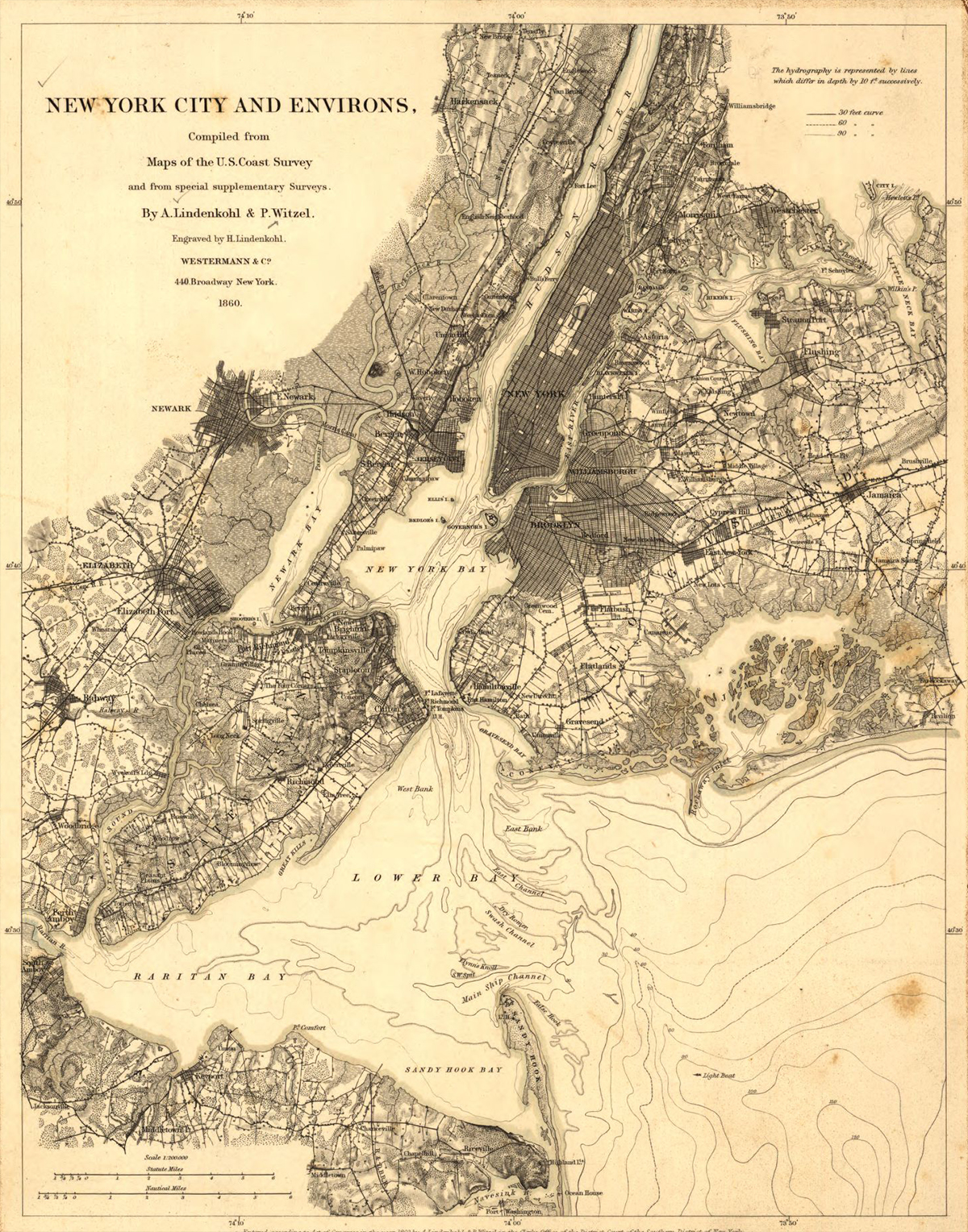
New York City in 1860 was thriving for some of the same reasons the city thrives today. The city’s location was then, and is now, central for the movement of people and freight to and from Europe and elsewhere. Waterways were the primary transportation pathways in 1860. New York’s deep and well-connected port, nearer to the ocean than the ports of other cities on the East coast of the United States, was a huge boon to shipping. The Hudson River connected New York City’s port to a wide gateway westward through the Erie Canal to Lake Erie and beyond. Europe sent and received goods and people across the Atlantic Ocean to New York. Cities on the Great Lakes could enjoy the benefits of shipping to and from Europe, completely by water!
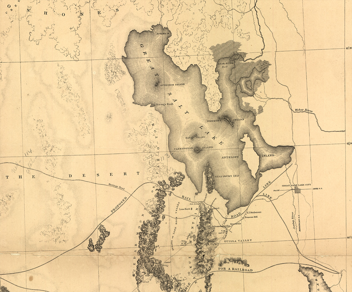
With imagination one can explore and understand how very different life was for people in the United States before the Golden Spike was hammered into the ground in Utah in 1869. That was a much-hailed event that knitted the country together by linking two railroad lines from the eastern and western ends of the continent. Just ten years earlier, when the map at left was made, life was more centered on local transactions. It was hard for families with children to visit friends because travel in this part of the country was slow and arduous, over bumpy dirt roads by horse and wagon. A life involving daily travel for several miles from home each day to work was not feasible. Yet change was in the air even then.
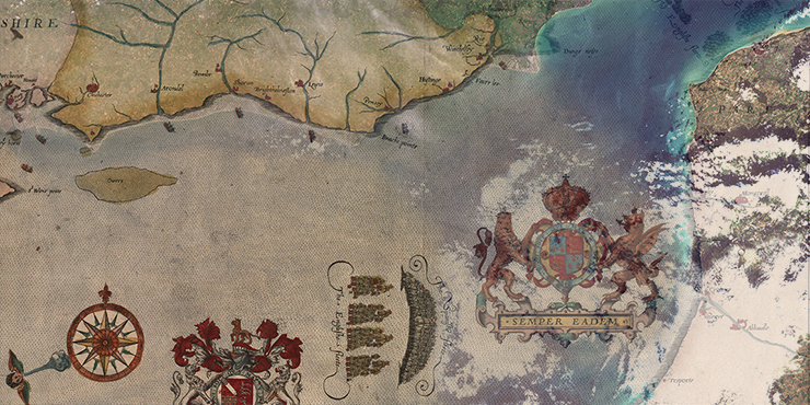
The series of battles that unfolds with these seven maps is considered one of the most important campaigns in naval history; a campaign that ended with the defeat of the powerful Spanish Armada in 1588. Cartographer Robert Adams created these maps for a 1590 book chronicling the famed naval campaign.
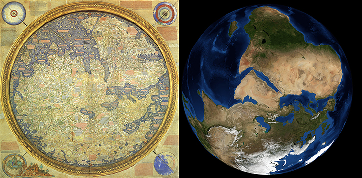
Long before the famous Earthrise photo taken by Apollo astronauts, creating an image or map of the entire known world was a singular human endeavor. Imagine a half a millennium earlier when only those who had traveled could describe distant lands. Imagine watching the hustle and bustle of merchants and sailors returning to the port of Venice. What stories could they tell to paint a portrait of our planet?
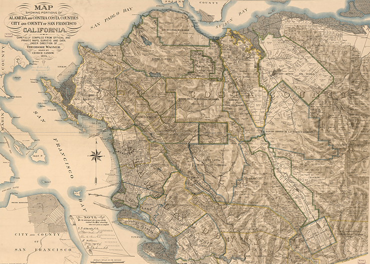
Maps often convey our relationship to the world. In this map of the northern San Francisco Bay and surrounding environs, the early development of the region is recorded in detail. The full and arduous title of this map is “Map showing portions of Alameda and Contra Costa counties, city and county of San Francisco, California, carefully compiled from official and private maps, surveys and data.”
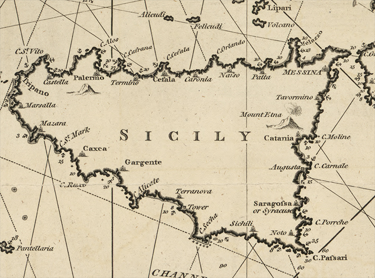
Maps often help us manage our world. In 1797, when cartographic engraver and chart publisher William Heatheri released his New Chart of the Mediterranean Sea, he had the needs of sea merchants foremost in mind.
The following problems apply the math skills listed in order to explore and understand various proceses that relate to the Landsat mission. The topics range
Featured Landsat Videos + G2009-120_Landsat_Flyby_MASTER_ipod_lg – A short overview of how Landsat benefits people. + Landsat 8 Launch – Landsat 8 blasts off on an
+ Download Landsat eBook [46.8MB PDF] The Landsat Data Continuity Mission (LDCM), renamed Landsat 8 after launch, builds on a rich legacy of service to
Do you like exploring and viewing Earth from space? Do you like using satellite images, maps and other geospatial data? Do you like thinking in
NASA Wavelength is your pathway into a digital collection of Earth and space science resources for educators of all levels – from elementary to college,
Landsat has a long history of exploring Earth from Space. Use these resources to learn more about How Landsat Works, How Landsat Benefits Society, and
Thank you for choosing to host the NASA Landsat traveling exhibit! The documentation included below is designed to help ensure that your hosting experience is
Setting up is easy. Once Landsat: Seeing in a Different Light arrives, follow these steps to set up: Unscrew the four bolts using a
Hosting an exhibit can be a great way to bring current satellite science to your institution. See how Landsat has been observing our changing planet
Congratulations on being selected to host Landsat: Seeing in a Different Light! Soon you’ll be exploring Earth through Landsat satellite images with visitors from your
Landsat: Seeing in a Different Light Landsat: Seeing in a Different Light engages its audience through asking them to select different locations around the world,
Landsat is more than just a camera with a great zoom lens orbiting Earth. Landsat measures light reflected by Earth from the sun. The light
Title Description Keywords DLESE (external link)Description For Grades K-12 Mission Geography (external link) These curriculum support materials link the content, skills, and perspectives of Geography
Student projects from summer 2005: Landcover classification specific to timber typing in the buffer zone of the Mission Range. This student was looking for dominant
