
A New and Improved Harmonized Landsat and Sentinel-2 Dataset
In July, 2025, a team of researchers unveiled the Harmonized Landsat and Sentinel-2 (HLS) version 2.0 surface reflectance dataset and algorithms.

In July, 2025, a team of researchers unveiled the Harmonized Landsat and Sentinel-2 (HLS) version 2.0 surface reflectance dataset and algorithms.

The Gran Chaco—South America’s second largest forest—is disappearing. Watch decades of forest change, as captured by Landsat satellites.

Between October 2023 and October 2024, the four dams of the Klamath Hydroelectric Project were taken down, opening more than 400 miles of salmon habitat.

Haiti lost nearly half of its primary forests between 1996 and 2022, with fires and tree-cutting being major drivers of loss, according to a new study.
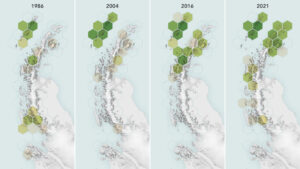
Using observations from Landsat 5 through Landsat 8, scientists determined that the area of vegetated land on the Antarctic Peninsula grew from 0.86 to 11.95 square kilometers (0.33 to 4.61 square miles) between 1986 and 2021.
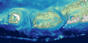
Scientists at the U.S. Geological Survey have developed a new way to measure ocean depth, or bathymetry, in shallow nearshore environments using Landsat data.
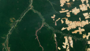
The Amazon is in trouble. Researchers found that, between 2000 and 2022, the Brazilian Amazon lost about 10% of its natural non-forest vegetation.
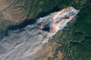
A new study tracks the shifting dynamics of wildfires in western North America. Using Landsat-derived datasets and active fire information from geostationary satellites, researchers found that fires are burning through the night more often—and drought is partially to blame.
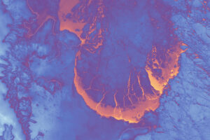
Landsat satellites have begun regularly acquiring images of ice at the poles during the winter, with enlightening results.
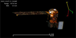
On October 7, 2022, Maxar’s WorldView-3 satellite snapped a sequence of images showing Landsat 8 in orbit.

This February marks the 10th anniversary of the launch of Landsat 8, launched by NASA in 2013 and operated by the US Geological Survey.
In Beck’s “Hyperlife” video, the abstract beauty of our planet morphs from geographic location-to-location with the flow of the etherial track.

Aaron Gerace and Matthew Montanaro earned the 2019 USGIF Academic Achievement Award for their work on the Landsat 8 TIRS stray-light issue.
Landsat 8 continues a streak of engineering and science success unmatched in spaceflight.
An advanced photodetector camera that traces its heritage to one now flying on Landsat 8 is being studied as a potential payload on a conceptual satellite (CapSat) system purposely designed to take advantage of the expected boom in secondary-payload launch opportunities.
Landsat 1 • Landsat 2 • Landsat 3 • Landsat 4 • Landsat 5 • Landsat 6 • Landsat 7 • Landsat 8 Landsat 8 launched on February 11, 2013, from Vandenberg Air Force Base, California, on an