By Landsat Science Outreach Team
You’ve probably seen artists’ renderings of satellites in orbit before, but have you seen an actual image of an orbiting satellite before?
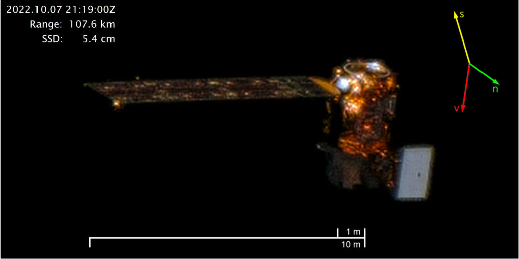
On October 7, 2022, Maxar’s WorldView-3 satellite snapped this sequence of images showing Landsat 8 in orbit. The distance between the satellites ranges from between 91.4 to 129.9 km (56.8 to 80.7 miles). The orientation arrows provide Sun, Nadir, and Velocity information. The resolution of the Landsat 8 images in this sequence varies from 4.6 to 6.5 cm (SSD stands for Space Sample Distance).
After Maxar’s WorldView-2 satellite was hit by a non-tracked piece of space debris in 2016, Maxar used another one of its satellites to image WorldView-2 and assess the amount of damage—it was minimal. With the density of satellites and space debris both growing, Maxar realized that other commercial and government satellite operators may also need similar satellite imaging services for better space domain awareness. Maxar posits that the imaging technology could help identify space objects, assess on-orbit collision risks, aid satellite maneuver planning, and monitoring of end-of-life deorbiting and deactivated satellites.
As of December 2021, Maxar holds a license for non-Earth imaging (NEI) of Low Earth Orbit (LEO) satellites. The Landsat 8 images were taken as a demonstration of this technology.