Fifteen Years of Open Data Allows Advancements in Landsat Use and Research

Fifteen Years of Open Data Allows Advancements in Landsat Use and Research

Excerpted from post by USGS Landsat Missions

On this day in 2008, the USGS announced their plan to ‘open’ their Landsat archives, making all Landsat data available to download at no charge, to all users worldwide. Fifteen years later, in the “Year of Open Science”, Landsat continues to lead how Earth Observation data is utilized, and how Landsat data is used to support science and research efforts. 
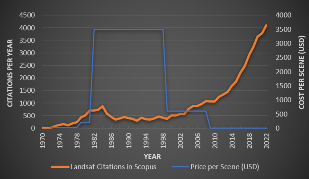
 

Graph showing how Landsat-based scientific citations increased greatly with the opening of the Landsat archive.
The number of Landsat-related citations (orange line) and the cost per scene (blue line) from 1970 to 2022. Image credit: USGS

Citations Increase with Open Archive

Prior to the opening of the Landsat archive in 2008, the costs of obtaining Landsat scenes were prohibitive to science research and applications. Sales of Landsat 7 ETM+ data peaked in FY 2001 with 19,000 scenes sold; in FY 2008, over 86,000 scenes were downloaded at no cost. In August 2009, downloads reached the one-million mark. (Reference: Landsat’s Enduring Legacy, page 345).  

While published works have always provided insights into the research done using Landsat data, the ability to obtain Landsat data at no charge has greatly helped researchers and scientists increase their publications and advance remote sensing science research.  

For more than 20 years, members of the USGS/NASA Landsat Science Teams have been instrumental in creating many published works to support the Landsat mission. Consisting of USGS and NASA scientists and engineers, along with external scientists, engineers, and application specialists representing industry and university research initiatives, the Team provides scientific and technical evaluations to ensure the continued success of the Landsat program.

Citations increased greatly after the data became freely available starting in December 2008.

Get the latest from Landsat in your inbox.


By submitting this form, you are consenting to receive marketing emails from: Landsat Science. You can revoke your consent to receive emails at any time by using the SafeUnsubscribe® link, found at the bottom of every email. Emails are serviced by Constant Contact
On Key

Recent Posts

Map shows South Korea with waterways highlighted. In the top right corner is a north arrow and in the bottom left corner is a legend of different rivers in South Korea.

Monitoring Water Quality in South Korea

South Korea is facing a water quality problem. Researchers Hyunglok Kim and Seongjun Lee from the Gwangju Institute of Science and Technology (GIST) embarked on developing a model to predict water quality indicators in near real-time.

Read More »
Landsat outreach specialist Allison Nussbaum and GEDI/UMD Faculty Specialist Talia Schwelling hold Landsat/GEDI postcards at the NASA exhibit booth at AGU24.

Landsat at AGU24

The NASA Landsat Science and Outreach teams attended the American Geophysical Union’s annual meeting in DC in December. At AGU24, they shared research and educated the public about Landsat.

Read More »
On Key

Related Posts

Map shows South Korea with waterways highlighted. In the top right corner is a north arrow and in the bottom left corner is a legend of different rivers in South Korea.

Monitoring Water Quality in South Korea

South Korea is facing a water quality problem. Researchers Hyunglok Kim and Seongjun Lee from the Gwangju Institute of Science and Technology (GIST) embarked on developing a model to predict water quality indicators in near real-time.

Read More »