
How Early Astronaut Photographs Inspired the Landsat Program
In the 1960s, NASA was pioneering a new era of human spaceflight—and astronaut photography—that would change Earth observation forever.

In the 1960s, NASA was pioneering a new era of human spaceflight—and astronaut photography—that would change Earth observation forever.
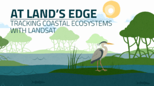
Discover how Landsat’s 50-year record of Earth helps scientists track the health of coastal ecosystems while providing tools to monitor water quality and reveal changes at the edge of land and sea.

Landsat-based National Land Cover Database (NLCD) helps predict hurricane wind risk to homes and other structures.

Using data from Harmonized Landsat and Sentinel-2 (HLS), researchers developed a new algorithm to better monitor reservoir water levels in the contiguous U.S.

The Landsat satellite program, with its unparalleled 53-year historic record, can reveal changes through the Annual National Land Cover Database (NLCD).

In July, 2025, a team of researchers unveiled the Harmonized Landsat and Sentinel-2 (HLS) version 2.0 surface reflectance dataset and algorithms.

The Gran Chaco—South America’s second largest forest—is disappearing. Watch decades of forest change, as captured by Landsat satellites.

As an avid Landsat user and an expert in commercial satellite data, Dr. Francois Smith spoke to how the private and public remote sensing sectors work together.

When the first Landsat satellite launched in 1972, it posed the following question: could we manage our natural resources using remotely–sensed data? The answer, 53 years on, is a resounding “yes.”

The USGS Earth Resources Observation and Science Center archive has more than one million Landsat 9 Level-1 products (that’s over 1 billion megabytes of data)!

Celebrating the 25-year mission of Landsat 7, a NASA/USGS satellite that revolutionized Earth observation with high-resolution imagery used in agriculture, disaster response, climate research, and more.

The Arctic is changing rapidly. Recent research unveiled a new dataset of 40 years of coastlines shifting across the Arctic.

The Landsat 7 satellite launched in April 1999 and will be decommissioned after 26 years in orbit. Its science mission, focused on collecting imagery data of Earth’s land and inland waters, spanned 25 years.

Between October 2023 and October 2024, the four dams of the Klamath Hydroelectric Project were taken down, opening more than 400 miles of salmon habitat.

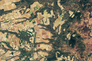
In this animation of 2024 and January 2025, crop fields in Saudi Arabia cycle through their growing seasons.

Using Landsat’s thermal imagery, researchers at Gallo Winery have been able to better understand vineyard water needs and optimize irrigation.

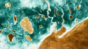
Landsat images show that in the past 40 years alone, Louisiana’s coastal wetlands have undergone substantial changes.

Haiti lost nearly half of its primary forests between 1996 and 2022, with fires and tree-cutting being major drivers of loss, according to a new study.

On April, 22, 2025, NASA celebrated Earth Day as only NASA can: with beautiful Landsat imagery of our home planet.

Data interoperability expert Dana Ostrenga explains how government and commercial Earth observation satellites provide broader support to the scientific community when used together.

Rising sea levels and increased ocean temperatures are supercharging hurricanes. Using satellite data can help monitor vulnerable ecosystems.

Why do we calibrate Landsat data? We spoke with Brian Markham, a key figure of Landsat calibration science for four decades. He said that it all comes down to this: “If we’re using a system to quantify changes on the Earth, we must make sure the system we’re using is not changing.”
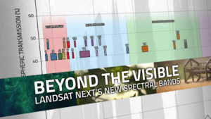
With Landsat Next’s 26 new spectral bands, we’ll be able to see our planet like never before. Landsat Next’s enhanced capabilities will provide scientists, farmers, and decision-makers with critical data to tackle global challenges.
A NASA and U.S. Geological Survey (USGS)-supported research and development team, OpenET, is making it easier for farmers and ranchers to manage their water resources with the FARMS tool.
New research led by Landsat 8/9 Project Scientist Chris Neigh used Landsat and ICESat-2 data to investigate how boreal forests growth could sequester carbon.
Using NASA data, researchers can track vegetation changes around the planet, not just in forests but also in grasslands and savannas like the Brazilian Cerrado.
Numerous artists have incorporated NASA science data into their work, further engaging the public in science discovery.
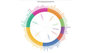
NASA’s Science Activation team has created a graphic to help K-12 teachers find out which NASA Earth Science missions can provide real-world data most relevant to their Next Generation Science-based lessons.

Grasslands tend to get left out of conservation discussion. New research from the World Resources Institute maps how they’ve changed over the past 20 years.

Wildfires have been increasing in frequency and size across North America in recent years. British Columbia is no exception to that trend; more than 4% of the heavily-forested province has burned since 2017. In 2023, Canada saw its worst wildfire season in recorded history. These high intensity fires affect ecosystem health and local economies, as timber is a major industry in BC.
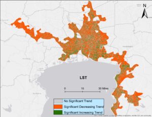
Looking at urban heat islands, researchers found that changing trends in vegetation influence land surface temperature in the Lower Mekong Delta cities.

Virginia Norwood is being posthumously recognized for designing the Landsat multispectral scanner system.

The USGS, in partnership with NASA, is calling for applications to staff the next Landsat Science Team to serve a 5-year term from 2025 to 2030.
