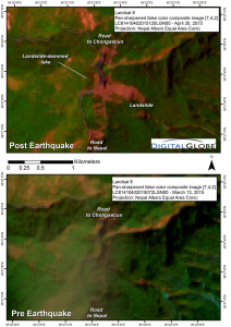
The landslide-dammed river flows south into Nepal, the border crossing being less than 4 miles (6 kilometers) south of the landslide. This feature is an example of the trans boundary nature and complex process chains of some natural disasters, where in this case an earthquake in one country (Nepal) triggered secondary hazards (a landslide and landslide-dammed lake) in another country (China), which poses a new hazard in both countries.
The pure scope and impact of the earthquake-triggered landslides has spurred a focused multinational response to locate and assess all river-damming landslides. The Chongsecun landslide was found by a Canadian government scientist (Ministry of Forests, Lands and Natural Resource Operations Canada) scrutinizing post- and pre-quake Landsat 8 images. A Chinese scientist at the Cold and Arid Regions Environmental and Engineering Research Institute (CAREERI), Chinese Academy of Sciences (CAS), in Lanzhou organized new satellite imaging of the area and a field investigation to assess the hazard posed by the landslide-dammed lake. The Chinese Gaofen-1 satellite obtained the first high-quality image on May 2, 2015, and then, beginning on May 3, Digital Globe’s satellites obtained a further series of high-resolution images. The satellite imagery has been studied by scientists in five nations. The scientists have determined that the impoundment lake had grown to 1,476 feet (450 meters) long by 164 feet (50 meters) wide by May 2. By May 3, the lake did not appear to have grown much further, but later images showed some growth in lake size and may indicate an elevating risk. The May 8 image gives an appearance that a second lake formed upstream. Additional high-resolution imagery and outburst flood modeling is needed to fully assess the lake hazard.
This international, multilateral collaboration is part of a nine-nation team of volunteer satellite image analysts, who are led by the University of Arizona and NASA’s SERVIR Applied Science Team. The team is systematically poring through an abundance of satellite imagery collected by space agencies around the world and the commercial company Digital Globe’s WorldView satellites. The volunteers report to a broader NASA-United States Geological Survey-Interagency Gorkha Earthquake Response Team and to Kathmandu-based ICIMOD and authorities in Nepal.
The images obtained and rendered for this product are:
+ Landsat 8: April 11, 2015 (pre-quake), and April 30, 2015 (false-color multispectral)
+ Gaofen-1: May 2, 2015 (panchromatic)
+ WorldView 1: May 3, 2015 (panchromatic)
+ GeoEye01: May 8, 2015 (pan-sharpened natural color)
+ WorldView 2: May 8, 2015 (pan-sharpened natural color)
Additional Resources:
+ NASA Activities related to Nepal Earthquake
+ International Disaster activation: Earthquake and landslide in Nepal and India
+ Mappers rush to pinpoint landslide risk in Nepal, Nature
+ Disaster response in Nepal and the Zooniverse
Image Credit:
Alexandre Bevington and Marten Geertsema, Government of British Columbia, Canada
Evan Miles, University of Cambridge, United Kingdom
Jakob Steiner, ETH Zürich, Switzerland
Jeffrey S. Kargel and Gregory J. Leonard, University of Arizona, Tucson
Dan Shugar, University of Victoria, British Columbia, Canada; and University of Tacoma, Washington
Joseph Shea, Dorothea Stumm, ICIMOD, Nepal
Lizong Wu, Liu Shiyin, Qi Yuan, and Donghui Shangguan, Cold and Arid Regions Environ-mental and Engineering Research Institute, Chinese Academy of Sciences, Lanzhou, China
Walter W. Immerzeel, University of Utrecht, Netherlands
Contact: Alexandre Bevington, Alexandre.Bevington@gov.bc.ca, (250) 565-6500


