Search
Close this search box.

Introducing the LandsatLook Viewer

Introducing the LandsatLook Viewer

Source: USGS Landsat Mission
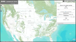
LandsatLook Viewer
USGS LandsatLook Viewer

In honor of the 40th Anniversary of the Landsat 1 launch, and in preparation for Landsat 8 in February 2013, the USGS has rolled out a prototype viewer that allows easy access to the over 3 million scenes in the Landsat archive. The LandsatLook Viewer utilizes ArcGIS Server technology to enable comprehensive searching and downloading of full-resolution LandsatLook images, along with access to Level 1 Data Products. Find out more about the LandsatLook Viewer.For more information:
+ LandsatLook Viewer specifics
LandsatLook Viewer
USGS Rachel Headley’s presentation at the ESRI UC (see “Afternoon Session”)

On Key

Recent Posts

Earthrise

Remembering Bill Anders

Anders, 90, the astronaut who captured the iconic Earthrise photograph, died on June 7, 2024, when the plane he was piloting crashed into the San Juan Channel.

Read More »
On Key

Related Posts