Landsat 3 was launched on March 5, 1978, three years after Landsat 2.
The Landsat program’s technical and scientific success together with political and economic pressures lead to the decision to commercialize an operational Landsat. To this end, responsibility was slated to shift from NASA (a research and development agency) to the National Oceanic and Atmospheric Administration (NOAA), the agency charged with operating the weather satellites. This was done via Presidential Directive/NSC-54 signed on Nov. 16, 1979 which assigned NOAA “management responsibility for civil operational land remote sensing activites.” (However, operational management was not transfered from NASA to NOAA until 1983).
Landsat 3 carried the same sensors as its predecessor: the Return Beam Vidicon (RBV) and the Multispectral Scanner (MSS). The RBV instrument on-board Landsat 3 had an improved 38 m ground resolution and used two RCA cameras which both imaged in one broad spectral band (green to near-infrared; 0.505–0.750 µm) instead of three separate bands (green, red, infrared) like its predecessors.
The MSS continued to systematically collect images of Earth using four spectral bands. A fifth thermal band was also part of the Landsat 3 MSS, however, the channel failed shortly after launch.
In March of 1983 Landsat 3 was put into standby mode; it was decommissioned on Sept. 7, 1983.
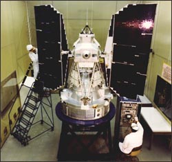
Landsat 3 in the cleanroom.
Quick Facts
Launch Date: March 5, 1978
Status: put into standby mode: March 31, 1983; decommissioned: Sept. 7, 1983
Landsat 1 • Landsat 2 • Landsat 3 • Landsat 4 • Landsat 5 • Landsat 6 • Landsat 7 • Landsat 8 Landsat 3 in the cleanroom. Landsat 3 was launched on March 5, 1978, three years after Landsat 2.
The Landsat program’s technical and scientific success together with political and economic pressures lead to the decision to commercialize an operational Landsat. To this end, responsibility was slated to shift from NASA (a research and development agency) to the National Oceanic and Atmospheric Administration (NOAA), the agency charged with operating the weather satellites. This was done via Presidential Directive/NSC-54 signed on Nov. 16, 1979 which assigned NOAA “management responsibility for civil operational land remote sensing activites.” (However, operational management was not transfered from NASA to NOAA until 1983).
Landsat 3 carried the same sensors as its predecessor: the Return Beam Vidicon (RBV) and the Multispectral Scanner (MSS). The RBV instrument on-board Landsat 3 had an improved 38 m ground resolution and used two RCA cameras which both imaged in one broad spectral band (green to near-infrared; 0.505–0.750 µm) instead of three separate bands (green, red, infrared) like its predecessors.
The MSS continued to systematically collect images of Earth using four spectral bands. A fifth thermal band was also part of the Landsat 3 MSS, however, the channel failed shortly after launch.
In March of 1983 Landsat 3 was put into standby mode; it was decommissioned on Sept. 7, 1983.