By Laura E.P. Rocchio
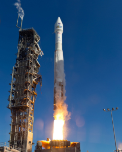
Five years ago, on February 11, 2013, Landsat 8 made its way into orbit. Since then, Landsat 8 has made over 26,500 trips around Earth adding more than 1.1 million scenes to the data archive—Landsat 8’s five years of image contributions represent nearly 16% of the entire 45-year collection.
“Data acquisition rates from Landsat 8 have enabled population of the archive at an unprecedented rate,” says John Dwyer, Chief of the Science and Applications Branch at the USGS Earth Resources Observation & Science Center where the Landsat Project is located and its archive maintained. For the vast majority of science applications this higher image collection rate is significant because it improves the chance of cloud-free acquisitions.
Sound science
Landsat 8 benefits from evolutionary technological advances over its predecessors. Landsat 8’s Operational Land Imager (OLI) collects data in two new spectral bands: a deep blue (coastal/aerosol) band and a cirrus cloud detection band. Both of Landsat 8’s science instruments, OLI and the Thermal Infrared Sensor (TIRS), can out perform their predecessors’ measurement sensitivity due to an improved signal-to-noise ratio (SNR).
These improvements have been integral to the work of water quality managers who can now use Landsat 8 to map water quality indicators in coastal and inland waters.
“We can now pull out detailed maps of water constituents, including chlorophyll, dissolved organic matter, and suspended sediment,” says Jeff Masek, the NASA Landsat 9 Project Scientist.
Landsat 8 has also made mapping the movement of glaciers, ice sheets, and sea ice easier. This in turn has led to the near-real-time global monitoring of glaciers, detailed Antarctic ice sheet velocity maps, and new Antarctic rock outcrop maps. All of which combine to give a better understanding of cryospheric processes.
Landsat 8 also detects more subtle changes in vegetation health and can help make meaningful measurements of biophysical variables that land managers track, like leaf-area index. The addition of the cirrus band, meanwhile, is helping across disciplines by identifying where thin, hard-to-see cirrus clouds are effecting measurements.
“I am thrilled by the performance of Landsat 8,” states NASA Landsat 8 Project Scientist Jim Irons. “And even more so by the adoption of the data by so many people for important, consequential research and applications.”
Check marks
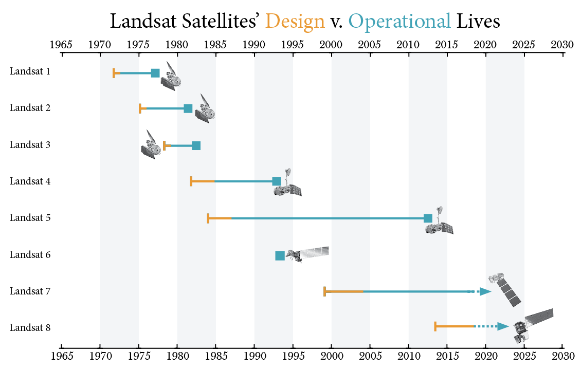
This five-year launch anniversary also marks an engineering milestone. Landsat 8 was built with a 5-year design life. In the engineering realm, design life is a concept that describes the timespan in which engineers are highly confident a satellite can perform on orbit without failure. The design life designation takes into account things like mean-time to failure for the satellite’s various components and redundancies (back-up components).
“In reality, most missions that survive their first few months on orbit tend to last much longer than their stated design life,” explains Masek. “Because the Landsat 8 instruments have few moving parts and the OLI instrument in particular has significant redundancy, we are hopeful that Landsat 8 can continue to collect data for many more years.”
Irons concurs saying, “I expect Landsat 8 to last well beyond its design life and continue operations deep into the next decade.”
The history of Landsat satellites’ operational lives support this prediction. The first three Landsats were built with 1-year design lives but the operational life exceeded the design life by at least four years for all of them. Landsats 4 and 5 were built with 3-year design lives, but operated well beyond that designation, Landsat 5 by nearly 29 years (a feat for the record books). And Landsat 7, launched in 1999, was built with a five-year design life and is now in its 19th year of operation, albeit with some degradation.

Fuel is often the fundamental limiting factor for a satellite’s operational life, barring any onboard hardware failures. Initial conservative estimates for Landsat 8’s operational life were 10-years.
Today, “due to the excellent on-orbit performance of the spacecraft and instruments, the USGS anticipates exceeding Landsat 8’s planned 10-year operational life,” says Steve Covington, the USGS Land Remote Sensing Program Principal Engineer.
With the inherent risks and variables of spacecraft operations, definitive satellite life expectances are hard to nail down, but like Landsat 5, Landsat 8 benefits from an oversized fuel tank and a talented flight operations team.
Landsat 8’s data quality and collection pace adds significantly to the Landsat data record. The combined Landsat archive with its depth, quality, and open access has exposed new avenues to better understanding our planet; and this record will continue into the future.
“Landsat 8 has been a tremendous success,” Masek says. “We look forward to 2020, when Landsat 9 will join Landsat 8 on orbit, providing very high quality data with 8-day observation frequency over the global land area.”
Related resources:
+ Landsat 8 Marks Five Years in Orbit
+ NASA and USGS Celebrate 5 Year Launch Anniversary of Landsat 8
+ Flickr Gallery: Landsat Marks Five Years In Orbit
+ USGS Video: Landsat 8: 5-Year Anniversary
+ USGS Video: Landsat 8 Completes 5 Years of Operation
+ NASA Video: Five Years of Landsat 8
added Feb. 15, 2018
+ Orbital ATK-Built Landsat 8 Celebrates Five Years in Space, Orbital ATK


