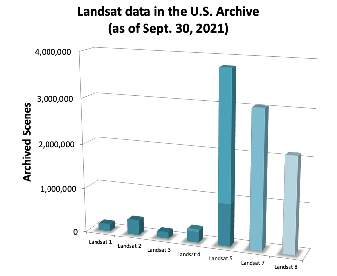
Since the launch of Landsat 1 in 1972, the Landsat mission satellites, a partnership between NASA and the U.S. Geological Survey (USGS), have produced more than 10 million images of Earth’s surface. This nearly 50-year record—the longest continuous global record of the Earth’s natural and human-induced surface change—is unmatched in quality, detail, and coverage, and provides a unique and valuable resource for people in a variety of professions, including agriculture, cryosphere, water resources, natural resource management, regional planning, and ecological and global-change research.
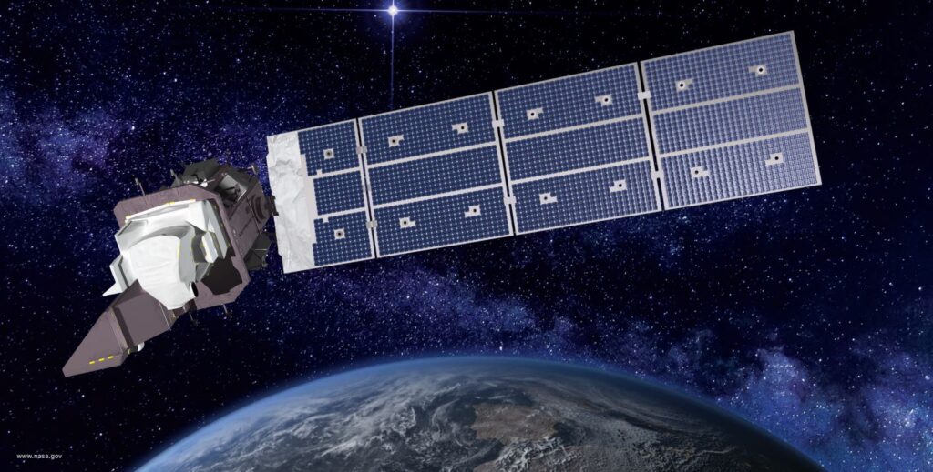
On September 27, 2021, the Landsat mission took a significant step toward continuing this long-term record of Earth observation with the launch of Landsat 9 from Vandenburg Space Force Base, located in California. Like its predecessor, Landsat 8, Landsat 9 will have a higher imaging capacity than earlier Landsat satellites, allowing for more data to be added to the Landsat global data archive.
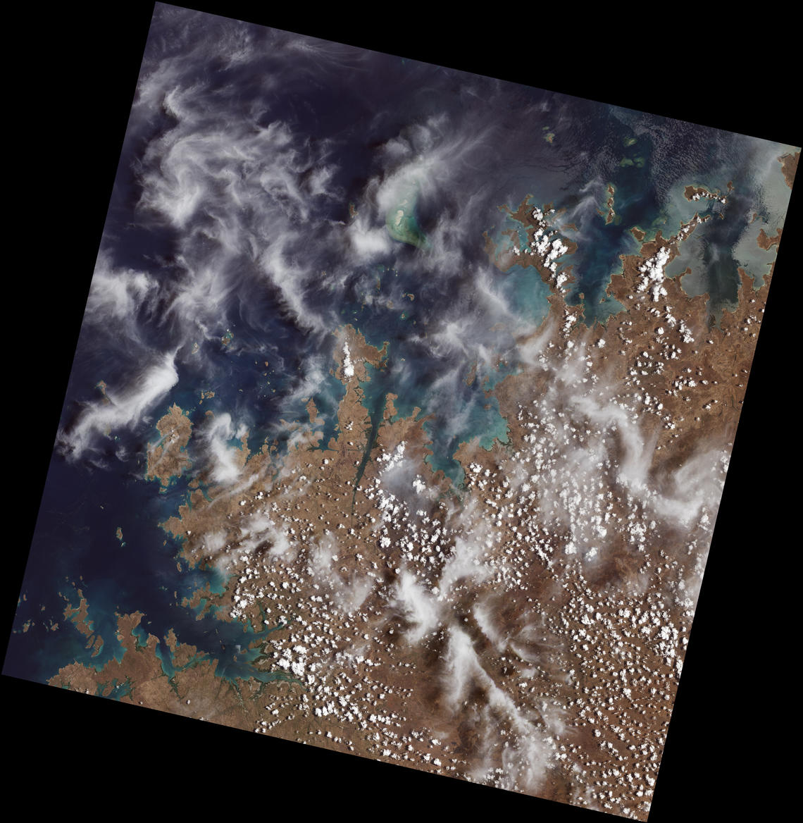
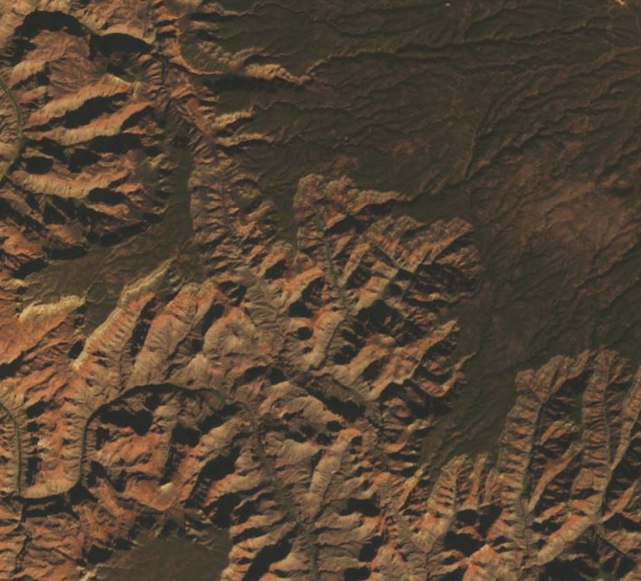
The Landsat mission offered a glimpse of Landsat 9’s capabilities when it released the first-light images from the satellite on October 31, 2021. These natural-color images of the Earth’s surface offer a preview of how the observatory will extend the mission’s long-term record of spaceborne Earth imagery.
“First light is a big milestone for Landsat users – it’s the first chance to really see the kind of quality that Landsat 9 provides,” said Dr. Jeff Masek, NASA’s Landsat 9 project scientist. “When we have Landsat 9 operating in coordination with Landsat 8, it’s going to provide a wealth of data, allowing us to monitor changes to our home planet every eight days.”
First light images are curated by NASA as part of the satellite’s 100-day post-launch commissioning and check-out period, which precedes the agency’s hand-over of the satellite’s control to the USGS (currently slated for January 2022). At that time, the Landsat 9 will be declared operational and the observatory will take the place of the aging Landsat 7. As Landsat 9 circumnavigates the Earth in a near-polar orbit, it will collect as many as 750 scenes per day at a 30-meter spatial resolution, and image almost the entire planet every 16 days. When it assumes Landsat 7’s position in the 705 km Earth Science constellation, Landsat 9 will be eight days out of phase with Landsat 8, giving the forthcoming Landsat 8 and Landsat 9 constellation a revisit time of 8 days (meaning the two satellites will cover nearly every point on Earth every eight days), as it currently is for Landsat 7 and Landsat 8. Orbiting in this configuration, together, both satellites will add nearly 1,500 new images to the USGS Landsat archive each day.
Yet, while Landsat’s 50-year record of 30-meter Earth observation is certainly noteworthy, USGS Landsat Project Scientist Dr. Christopher Crawford says there are other aspects of the Landsat mission that differentiate it from and make it a complement to the other well-known Earth-observing satellites, such as the joint NASA/NOAA Suomi National Polar-orbiting Partnership (Suomi NPP) and NOAA-20 missions, and NASA’s Terra and Aqua missions.
“[Landsat’s] spatial resolution, spectral continuity throughout the mission lifetime, coincidental acquisition of reflected and the thermal infrared data, and 8-day revisit coverage for everywhere on Earth for approximately two-thirds of the entire history of the Landsat mission, is really kind of unique,” he said. “Even though Landsat 9 was considered a clone or a rebuild of Landsat 8, Landsat 9 and 8 still remain distinctive within the Earth observation domain because of these sensing capabilities.”
Landsat 9’s extension of the mission’s continuity is significant as well, said Crawford.
“Landsat 9 is really a land imaging cornerstone in guaranteeing that we’ll continue to have the types of surface measurements that we’ve had for nearly 50 years, and I think that’s significant,” he said. “The user community that has developed science and application advancements around Landsat 8 will now get two observatories that are nearly identical, and we can expect to have a high-quality and reliable data stream for the next 10-plus years while Landsat continues to evolve into the future.”
The USGS manages this high-quality and reliable data stream through a collections strategy that applies consistent processing standards to all mission data.
“The collections are designed to apply consistent calibration and data processing to facilitate time-series analysis of Earth surface properties, their condition and their change over time in a manner that allows users to compare one image to the next within a season or across years,” said Crawford. “So, users know that they can now compare data that has been acquired by Landsat 7 or Landsat 8, back with Landsat 4 and Landsat 5.”
Further, this strategy offers an effective way for the mission to bring in new data, such as the forthcoming imagery from Landsat 9.
The Landsat data archive has two data collections—Collection 1 and Collection 2. Collection 1 consists of Level 1 data products generated from the Operational Land Imager (OLI) and Thermal Infrared Sensor (TIS) aboard Landsat 8, the Enhanced Thematic Mapper Plus (ETM+) aboard Landsat 7, the Thematic Mapper (TM) aboard the Landsat 4 and 5 satellites, and the Multispectral Scanner (MSS) instruments aboard Landsat satellites 1 through 5.
These Level 1 products are assigned to one of three tiers—Real Time, Tier 1, and Tier 2—based on their geometric quality and level of processing precision. Data placed in the Real-Time tier are made available for download in less than 12 hours after observation (typically in 4-6 hours) for immediate use by applications that require low latency observations. Landsat images with the highest available data quality are placed into Tier 1 and are considered suitable for time-series science analysis. Tier 1 includes Level-1 Precision and Terrain Corrected data that have well-characterized radiometry and are inter-calibrated across all Landsat instruments, Landsat 8 being the reference standard. Images that do not meet Tier 1 criteria during processing are assigned to Tier 2. Tier 2 scenes adhere to the same radiometric standard as Tier 1 scenes, but do not meet the Tier 1 geometry specification due to less accurate orbital information, significant cloud cover, insufficient ground control, or other factors.
Landsat Collection 2, the second major reprocessing of the Landsat archive, offers several data product improvements that capitalize on the recent advancements in data processing, algorithm development, and data access and distribution capabilities. Collection 2 includes Landsat Level-1 data for all sensors since 1972. (These Level 1 data are organized using the same tiered inventory structure as those in Collection 1.) It also contains global Level-2 surface reflectance and surface temperature scene-based products from 1982 to present within defined constraints. [Users should note that Landsat Collection 1 based forward processing will remain in effect through December 31, 2021, concurrent with Landsat Collection 2 based forward processing. Starting January 1, 2022, all new Landsat acquisitions will be processed into the Collection 2 inventory structure only.]
Landsat Collection 2 features several improvements over Collection 1, including updated global digital elevation modeling sources and calibration and validation updates. Most notably perhaps, Collection 2 offers substantial improvement in the absolute geolocation accuracy of the global ground reference dataset, which improves the interoperability of the Landsat archive through time.
“Landsat 8 has an exceptional ability to point and image. We took that performance and applied it to the full Landsat archive, and then we worked with the European Space Agency (ESA) to incorporate the Sentinel-2ground control, said Crawford. “Now for the first time with Collection 2, we have a more internally consistent Landsat pixel geometry, and it is harmonized to the Sentinel-2 satellite data record so users can now begin to use these two datasets together more confidently.”
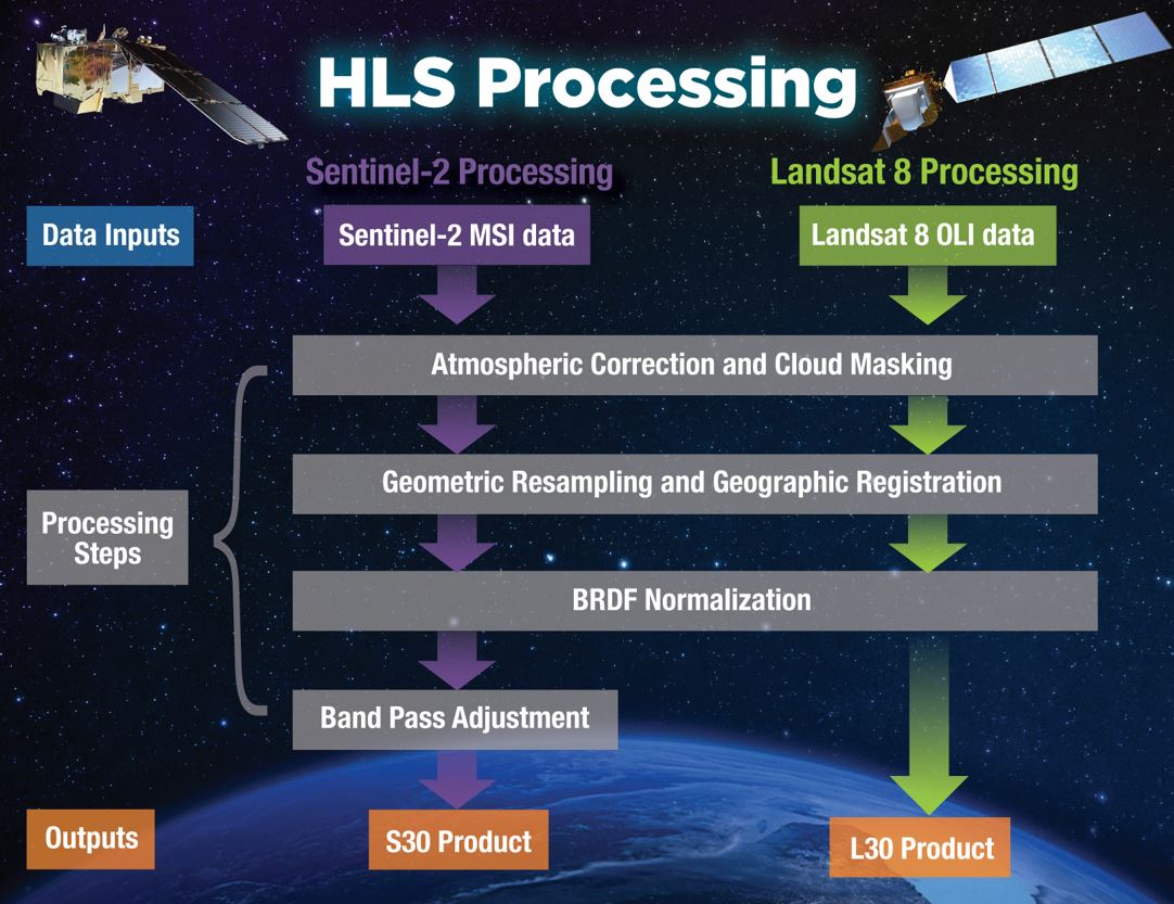
The harmonization of Landsat and Sentinel data is important, as it will enhance data products from initiatives like the Harmonized Landsat Sentinel-2 (HLS) project, which uses data from the joint NASA/USGS Landsat 8 and ESA’s Sentinel-2A and -2B satellites to generate a harmonized, analysis-ready surface reflectance data product available every two to three days. Data from Landsat 9 will be incorporated into the HLS data stream sometime in 2022, after the satellite is deemed operational.
In addition to these improvements, the Level 1 and 2 products of Landsat Collection 2 are available in a Cloud Optimized Georeferenced (COG) TIFF. COGs are an extension of the current GeoTIFF file format, which improves access to geospatial datasets in a cloud-based environment by letting users request only the bands they need.
Both Landsat collections offer Level 2 and Level 3 Landsat Science Products and Landsat Analysis Ready Data(ARD). The Level 2 and 3 science products are research-quality, application-ready products derived from Landsat Level-1 data, and can be used to monitor, assess, and project how changes in land use, land cover, and land condition might affect people and the environment. In contrast, the ARD products are processed to the highest level of processing required for direct use in monitoring and assessing landscape change. Therefore, the ARD products require less processing by end-users and removes the need for them to download and prepare large amounts of data for time-series analyses.
Landsat ARD products are available for the conterminous United States (CONUS), Alaska, and Hawaii using data from Landsat 8’s OLI and TIS, Landsat 7’s ETM+, and Landsat 4’s and 5’s TM. Landsat 9’s ARD products will become available after data processing systems produce the newly acquired data to the ARD tiles.
Aside from the USGS’s Landsat Collections, users can access Landsat data through NASA’s Land Processes Distributed Active Archive Center (LP DAAC), which is located within the USGS Earth Resources Observation and Science (EROS) Center in Sioux Falls, South Dakota. LP DAAC ingests, processes, archives, and distributes data products related to land processes in NASA’s Earth Observing System Data and Information System (EOSDIS) collection and its data are used to monitor the Earth’s land dynamics and environmental systems and enhance interdisciplinary research, education, and decision-making.
Landsat data are also available through NASA EOSDIS data discovery tool Earthdata Search, and through tools like the Application for Extracting and Exploring Analysis Ready Samples (AppEEARS), a data subsetting application that provides data access and value exploration for a variety of datasets from federal archives.
“For users of land remote sensing data, if they want Landsat or Moderate Resolution Imaging Spectroradiometer (MODIS), they shouldn’t have to go to this data access point, or that data access point. They want to see these things together,” said LP DAAC Project Scientist Tom Maiersperger. “So, we have worked with [the USGS] to bring Landsat and other land remote sensing assets together in an easy way. Of course, with Landsat 9, we’ll just be extending that partnership and that [data] record.”
Land processes data users can access USGS-developed tools as well, including EarthExplorer, which provides online search, browse display, metadata export, and data download of Landsat, aircraft, and other remote sensing inventories, and Landsat Look 2.0, a new tool that allows rapid online viewing and access to Landsat Collection 2 data in the cloud.
These tools allow the USGS to provide access to Landsat data in ways that meet a range of user needs, said Crawford.
“EarthExplorer is our legacy interface and Landsat Look 2.0 is a search and discover tool that allows users to look at the data directly in the cloud,” he said. “We’re trying to offer the legacy downloads for users who prefer to operate in that environment, and then we’re also trying to offer next generation capability in the cloud so [users] can work directly with the data in the cloud without having to download it, which does come at the user’s expense.”
LP DAAC is making similar moves toward the cloud.
“As we move forward, our traditional methods of direct downloads, search, and discovery will persist, but there is a new thrust that we’re going to have to start developing analysis in place, the ability for people to take their workflows to the cloud and work cloud natively with the data,” Maiersperger said. “We do have recipes and helper scripts and we have some HLS tutorials that can be run in a cloud-to-cloud environment, but we’re just at the beginning. We’ve got NASA’s Open Science initiative so, in the coming years, we’re going to see a lot of changes in how data are accessed and how assets are leveraged in the cloud.”
Yet, while the ways users access and analyze spaceborne land processes data may change, one of its primary sources—Landsat—will remain as enduring and consistent as ever.
Landsat was synonymous with land remote sensing for a few decades before we got these other types of instruments, and so it was the pathfinder, and it established the precedent for land remote sensing science,” said Maiersperger. “It kind of frames the whole community in some sense, and there’s an expectation that there will be continuity.”
With launch of Landsat 9 last September, it seems those expectations will be met for years to come.

