
Source: USGS Landsat
Sample Landsat ARD products and product information are available on the Landsat ARD webpage. This page also provides useful documentation such as the Data Format Control Book (DFCB) and will soon include a path/row tile converter tool.
=•=
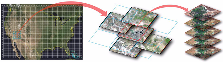
Landsat Analysis Ready Data (ARD) are consistently processed to the highest scientific standards and level of processing required for direct use in monitoring and assessing landscape change. A fundamental goal for Landsat ARD is to significantly reduce the magnitude of data processing for application scientists, who currently have to download and prepare large amounts of Landsat scene-based data for time-series investigative analysis. Landsat Collections Level-1 precision and terrain-corrected scenes serve as the input for generating all Landsat ARD products.
=•=
U.S. Landsat ARD products consist of the following higher-level data, which are processed using per-pixel solar zenith angle corrections, gridded to a common cartographic projection, and accompanied by metadata to enable further processing for the user while also retaining the traceability of data provenance:
Top of atmosphere (TA) reflectance
Brightness temperature (BT)
Surface reflectance (SR)
Pixel quality assessment (QA)
=•=
For further details, please visit the USGS Landsat Analysis Ready webpage.

Be Part of What’s Next: Emerging Applications of Landsat at AGU24
Anyone making innovative use of Landsat data to meet societal needs today and during coming decades is encouraged to submit and abstract for the upcoming “Emerging Science Applications of Landsat” session at AGU24.


