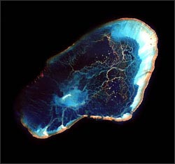
Detailed global coral reef maps created with Landsat 7 imagery have enabled scientists to determine which reefs have adequate protection.

It is well documented that coral reef biodiversity is in decline due to anthropogenic influences such as over fishing, coastal development, and pollution. Using Landsat-derived coral reef maps in conjunction with an updated inventory of Marine Protected Areas (MPAs), a team of international researchers reported in the June 23, 2006 issue of Science that only 2% of the world’s coral reefs within MPAs have adequate protection against declining biodiversity.
The updated inventory found that there are 980 MPAs covering 98,650 km² of the world’s coral reefs, but the limited size, management, and enforcement of these MPAs greatly reduces the effectiveness of their habitat protection.
Based on this research, the paper’s authors were able to make recommendations about both expanding and establishing new MPAs.
In 2003, the NASA-funded Millennium Project released its global collection of Landsat 7 coral reef images. Analysis of these 1,724 images by the University of South Florida’s Institute for Marine Remote Sensing resulted in an exhaustive global map of the world’s 527, 072 km² of coral reefs. The scattered distribution and relatively small size of individual reefs had made the creation of accurate and complete global coral reef maps impractical before Landsat 7.
+ Read NASA press release
+ Landsat 7 coral reef inventory announcement (PDF)

Data Wrangling with Dana Ostrenga
Data interoperability expert Dana Ostrenga explains how government and commercial Earth observation satellites provide broader support to the scientific community when used together.


