
Perry is able to link land use and land cover change information (including Landsat-derived forest cover) with other ancillary data to predict water quality, such as the amount of phosphorus (which feeds algae) in the lakes. These predictions can help prioritize where Great Lakes Restoration Initiative dollars should be spent.
Presentation title:
Linking land use/land cover change to phosphorus and sediment runoff in the Great Lakes basins
What insight did you gain from Landsat that would have been impossible to glean otherwise?
Perry: “The issue of forest disturbance could not have been addressed without our analysis of Landsat Time-series Stacks (see Stueve et al. 2011 and Zimmerman et al. 2013).”
Perry’s abstract:
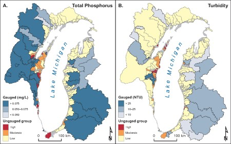
The Great Lakes Restoration Initiative (GLRI) is a multi-agency partnership supported by a multi-billion dollar investment by the U.S. Environmental Protection Agency. One major focus outlined in the GLRI Action Plan is “reducing nutrient runoff that contributes to harmful/nuisance algal blooms.” For the past several years, the USDA Forest Service has engaged in a comprehensive assessment of the character and trends of landscapes in watersheds draining into the Great Lakes as a means of prioritizing agency investments targeting nutrient and sediment reductions. Assessments in the Lake Superior and Lake Michigan basins utilized existing inventory collected by the Forest Service, and landscape trends were extracted by processing Landsat Time Series Stacks (LTSS) using the methods outlined by Stueve et al. (2011) and validated according to the process described by Zimmerman et al. (2013). These data were combined with ancillary datasets and documented the link between land use and water quality in the Lake Superior and Lake Michigan basins (see Seilheimer et al. 2013). While the resulting models were useful at prioritizing investments in basins with water quality observations, the greater benefit was prioritizing investments in landscapes lacking water quality measurements. Having demonstrated the linkage between land and water quality in the western basins, we are now completing similar prioritizations of the eastern Great Lakes (Lakes Huron, Erie, and Ontario). The process is largely similar, but we are implementing the Forest Service’s novel Landscape Change Monitoring System to process the LTSS. This new approach offers improved estimates of land use and land cover change, noticeably reducing errors of both commission and omission. Taken together with existing ancillary data, we expect the linkages between land use and water quality to be even stronger, and the prioritizations of ungaged basins to be even more robust.
Co-authors:
Mark Nelson
USDA Forest Service
James Garner
USDA Forest Service
Anyone can freely download Landsat data from the USGS EarthExplorer or LandsatLook.
Further Reading:
+ Linking Land Use to Water Quality
+ Landsat at #AGU15


