Source: UNBC Stories, University of Northern British Columbia
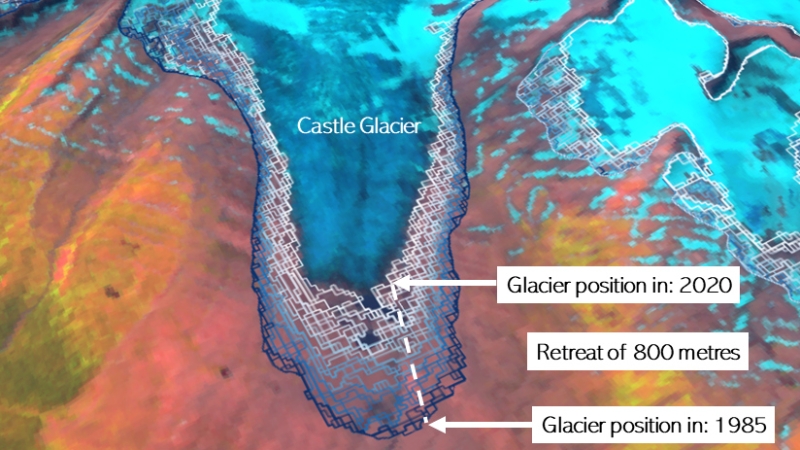
Using thousands of satellite images, investigators at the University of Northern British Columbia developed a novel method to systematically map and analyze changes in glacier and proglacial lakes within British Columbia and Alberta.
Their results were published in paper titled Accelerated change in the glaciated environments of western Canada revealed through trend analysis of optical satellite imagery in Remote Sensing of Environment, an international journal that focuses on earth observations from aircraft and satellites.
The new mapping method uses publicly available satellite imagery from the Landsat program which is available for analysis through Google Earth Engine, a cloud-based platform for planetary-scale data analysis.

Unlike previous change detection studies employed on glaciers, the researchers developed a workflow to map changes glacier extent and proglacial lake growth at yearly time scales over the period 1984-2020. The researchers found that glaciers shrank seven times faster over the period 2011-2020 than during the period 1984-2020. Accelerated area loss was highest for small glaciers on Vancouver Island where they experienced a 32-fold increase in the rate of shrinkage.
“Glaciers are shrinking very quickly,” says UNBC PhD candidate Alex Bevington, the paper’s lead author. ”Without satellite imagery it would be nearly impossible to monitor how glaciers of western Canada change year-to-year. Our data provides an updated inventory of glacier change which is needed by water managers and the scientific community.”
Glaciers represent a critical source of stored freshwater in western Canada. Human-induced climate change continues to threaten their existence. In addition to glacier retreat, researchers were able to show the area of proglacial lakes grew five times faster over this last decade.
”Accelerated glacier retreat exposes unstable slopes that can suddenly fail,” says Dr. Brian Menounos, the Canadian Research Chair in Glacier Change. ”An increase in lakes adjacent to unstable slopes elevates the likelihood for flood hazards downstream of these lakes if they were to suddenly fail.”
Reference
Bevington, Alexandre R., and Brian Menounos. 2022. “Accelerated change in the glaciated environments of western Canada revealed through trend analysis of optical satellite imagery.” Remote Sensing of Environment 270. doi: 10.1016/j.rse.2021.112862.


