
By Laura E.P. Rocchio
Each day of 2017, a project called Landsat365 is sharing a stunning Landsat 8 image with the public. Logan Byers, conceived of the project to celebrate the marvel of satellites and the places they image. The University of Kansas-trained glaciologist has challenged himself to find and share a beautiful place on Earth—captured by Landsat 8—each day. When we talked, Byers was approaching the 100th day of the project. Here is what he shared with us:
Could you explain the Landsat365 project?
Landsat365 is a digital art project spanning 2017, where I am posting a selected image from the Landsat 8 archive each day. These may be false-color composites or true-color images, but each is the same size and original ~30m resolution. The idea is that the images are at pixel-perfect resolution for some Apple computers so that they can be used as desktop wallpapers, but they are also digital images that people can download and use or just check out. There are many places on Earth that don’t get attention or that you may never know about. This project is capturing some of those places and sharing the way that Landsat has seen them.
How did you first become acquainted with the Landsat program?
My first experiences with the Landsat program were during the senior year of my undergraduate curricula. I was performing research in a laboratory that studied glacier dynamics and ice sheet processes, and was baffled by the concept of being able to sit in the middle of the continental U.S. while looking at Antarctica and also cycling through images to watch glaciers move and snow shift across the ice sheet. It was fantastic and a little unbelievable that there were so many free and open images from the archive. I was also using the Landsat Image Mosaic of Antarctica (LIMA) put together by Bob Bindschadler and others to map out crevasses across the East Antarctic Ice Sheet, which was my first introduction to the quantitative applications and image processing techniques of satellite remote sensing.
For your Landsat365 project, how do you decide where in the world to set your sights each day?
It is certainly a challenge to find diverse and interesting parts of the planet each day. Diversity can be a challenge to maintain day over day. I try to ensure there aren’t too many red deltas or yellow desert scenes in a row. Earth only has so many biomes and each image that is part of the Landsat365 collection is cropped to the same scale and extent (about 85 km by 55 km). There is a definite potential to exhaust certain areas and I don’t want to do that too soon. Namibia is a great example of this concern. There are some amazing textures and features in that country and I am trying to hold back and save some areas for later. You have to carefully use your resources.
Beyond that, there are the working conditions of the scene geometry and breaks along rows that limit the areas to qualify. There are so many interesting features that are located on or near path/row boundaries. Path edges will continue to be an impediment, but I suspect that some multiple along-path scenes will pop up later in the year as I look to capture some features that were passed by earlier.
Lastly, there are some web-based tools I have been using to help search for candidate scenes. The main interface I am using to search for scenes is through Remote Pixel. That site features a webmap that shows the scene boundaries overlain on a satellite basemap and quickly points to open data repositories to download the Level 1 data. That has a been a real benefit in terms of quickly identifying interesting features that are soundly within a scene.
Is there an image that is your personal favorite so far?
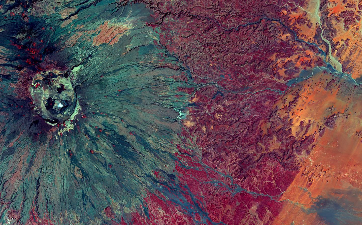
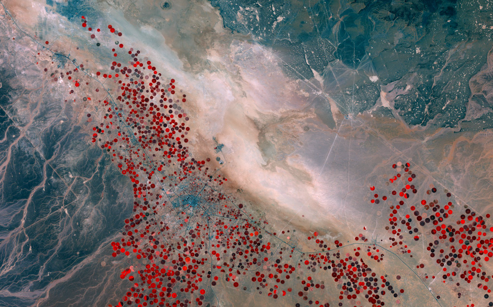
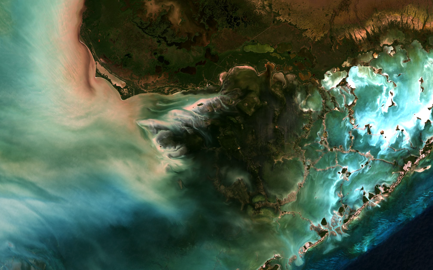
It is challenging to pick one, of course. There is a growing set that I adore and which continue to provide the same wonder when I look at them as when they were posted. The image of Emi Koussi in Chad (2017-015) is the first to come to mind. Everything in that image calls to me—the textures, the colors, the composition—I just love it. The image of Tabarjal, Saudi Arabia (2017-045) is also a favorite. That image was posted on Valentines Day and was planned out a bit in advance. The center-pivot irrigation systems look like poppies or some flowers and the roads connecting settlements remind me of constellation charts. There is a dry lake in the center of the scene that is shrouded in gold and is shaped a bit like a bird. I think overall it is a very ethereal scene. As a last image I will choose one that is more grounded and recognizable as an image of Earth. The image of Florida Bay and Everglades National Park (2017-089) has a depth and dimensionality that isn’t too common in other images. Driving that is luscious water that looks like satin. I think that is a scene that will get some more advanced image processing in the future to really take it over the top.
How do you decide which spectral band combination to use for each image?
It was more of a challenge over the first month or so as I would experiment with 2 to 5 band combinations for any scene. I have since grown an intuition for matching scenes with aesthetics and pretty much keep to what I know works. Desert scenes look good when Red is replaced by SWIR and maybe Green is replaced by Red to make the sand a little more yellow. I have gained a much greater understanding of light mixing than I had before this project, even though I have always enjoyed photography. The infrared bands still surprise me in how they can alter a scene from its true-color counterpart.
Has it been challenging to post an image each day? / How do you make time in your day to do this?
It has been a challenge to share a post each day. I also post on twitter and instagram which takes some additional time. For a while I was ahead of schedule and had a decent backlog of images that I could share. This greatly reduced the time spent on finding and processing the images, but those days have passed.
The small description that accompanies each image can sometimes be the most time consuming part of each day. If the image is of some remote plateau in the Sahara, I usually try to seek out its name or some named feature within the image to specify the location/title for the image. In other cases I might need to write about a river in Southeast Asia and that leads down a path of deciding on the spelling and researching about that waterway. Sometimes it’s impossible to find the information trail and other times I wind up with 14 open internet tabs about the area and haven’t decided on what to write for the description. I really wish I could put more quality into the descriptions but it can be a total time sink.
In terms of the actual processing I have spent some upfront time setting up scripts to automate the repeated tasks and simplify the workflow. That has been a huge time saver and it allows for more iteration when deciding on the exact cropping or band stretching. I still enjoy hunting down new areas and playing with the band scalings to see what is out there on Earth so it isn’t too much of a chore.
Has this project given you any new insights about the surface of the Earth?
There have been many new insights, but the greatest amount of knowledge I have gained is in geography. I have a much better grasp of countries, their shapes, their provinces/states, rivers, mountains, etc than I had before. I am looking forward to trivia night. I have also learned more about the scale of Earth’s features. Keeping each of the images the same size and scale reveals the magnitude of impressive structures on Earth such as Asia’s great rivers and volcanic shields in the Sahara Desert. Conversely, the texture and intricacies of Landsat 8 imagery capture biologic and physical systems operating at a completely different scale. There have been some real insights gained into places in the U.S. that I previously visited and have now shared as part of Landsat365.
Any use of trade, firm, or product names is for descriptive purposes only and does not imply endorsement by the U.S. Government.


