
Jan 27, 2020 • The International Disaster Charter is a system that supplies free satellite imagery to emergency responders anywhere in the world.
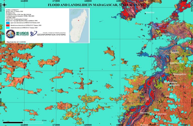
Recently, the NASA/USGS Landsat 8 satellite was among the space-based resources used to help map the shifting situation on the ground in Madagascar after heavy rainfalls. Here is the event description from the International Disaster Charter:
Heavy rainfall throughout January has triggered flash flooding and landslides across several areas of Madagascar. At least 12 people have been killed with 18 more reported missing. Madagascar’s disaster agency BNGRC, reported the capital city Antananarivo suffered severe damage from flooding where 500 people were affected and 40 houses were destroyed. The University of Antananarivo was also badly affected and had to be closed. Four fatalities were reported due to flash floods and landslides across Antananarivo. Two more people were killed after being washed away by floodwaters in Andapa, northern Sava Region. Heavy flooding was also reported in the port city of Mahajanga in the Boeny region, where over a thousand people are affected with many being evacuated and placed in temporary accommodation. The Sambirano River in the Diana region had a rapid increase in water levels and began to burst its banks. Red warnings for heavy rain were issued for areas in north-western Madagascar, while red warnings for strong winds and high waves were in place for the country’s coastal western area. The Government declared a State of Emergency on 24 January and is leading the humanitarian response. Severe weather conditions including further rainfall are forecast for the coming days.
The International Disaster Charter concept is simple: authorized parties have 24/7 contact to a person who can activate the charter. Once activated, a project manager takes charge. The project manager knows what satellite resources are available, how to task them to collect data, and how to quickly analyze the collected data to create impact maps for first responders. These maps, provided to responders for free, often show where the damage is and where crisis victims are, allowing responders to plan and execute relief support.
You can think of the International Disaster Charter as a one-stop-shop for impact maps—an essential resource, since in many cases satellite data are the only practical method to assess current ground conditions after a disaster.
Related reading:
+ Flood and Landslide in Madagascar, International Disaster Charter Activation
+ Flood Waters Overwhelm Northern Madagascar, NASA Earth Observatory
+ Mapping Disaster: A Global Community Helps from Space


