
The NLIR Project is composed of two components. The first component is focused on the development of the Earth Observation Requirements Evaluation System (EORES) to capture, store and analyze user requirements, whereas, the second component is the mechanism and processes to elicit and document the user requirements that will populate the EORES.
To develop the second component, the requirements elicitation methodology was exercised and refined through a pilot project conducted from June to September 2013. The pilot project focused specifically on applications and user requirements for moderate resolution imagery (5–120 meter resolution) as the test case for requirements development.
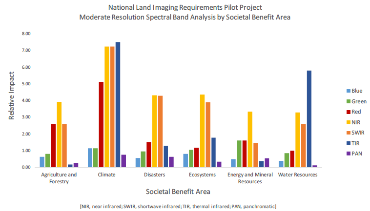
The purpose of this summary report is to provide a high-level overview of the requirements elicitation process that was exercised through the pilot project and an early analysis of the moderate resolution imaging user requirements acquired to date to support ongoing USGS sustainable land imaging study needs.
The pilot project engaged a limited set of Federal Government users from the operational and research communities and therefore the information captured represents only a subset of all land imaging user requirements. However, based on a comparison of results, trends, and analysis, the pilot captured a strong baseline of typical applications areas and user needs for moderate resolution imagery.
Because these results are preliminary and represent only a sample of users and application areas, the information from this report should only be used to indicate general user needs for the applications covered. Users of the information are cautioned that use of specific numeric results may be inappropriate without additional research. Any information used or cited from this report should specifically be cited as preliminary findings.
+ National Land Imaging Requirements (NLIR) Pilot Project summary report: summary of moderate resolution imaging user requirements, 2014, Vadnais, Carolyn; Stensaas, Gregory; USGS Open-File Report: 2014-1107

Be Part of What’s Next: Emerging Applications of Landsat at AGU24
Anyone making innovative use of Landsat data to meet societal needs today and during coming decades is encouraged to submit and abstract for the upcoming “Emerging Science Applications of Landsat” session at AGU24.


