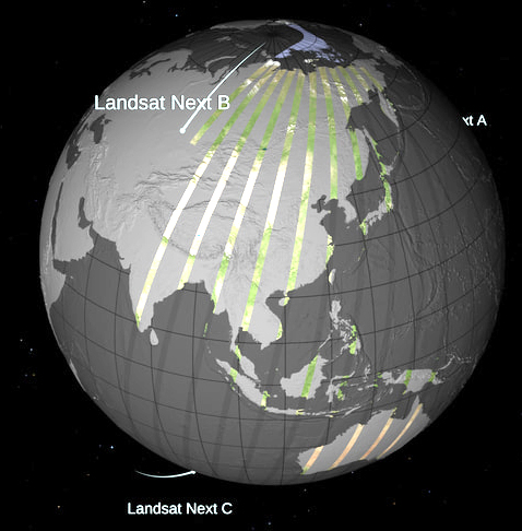
Released: Landsat Next Instrument Suite (LandIS) Draft Request for Proposal
The Landsat Next Instrument Suite Draft Request for Proposal is available for review via SAM.gov as of Monday, Feb. 13, 2023.

The Landsat Next Instrument Suite Draft Request for Proposal is available for review via SAM.gov as of Monday, Feb. 13, 2023.
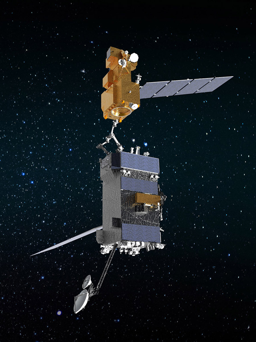
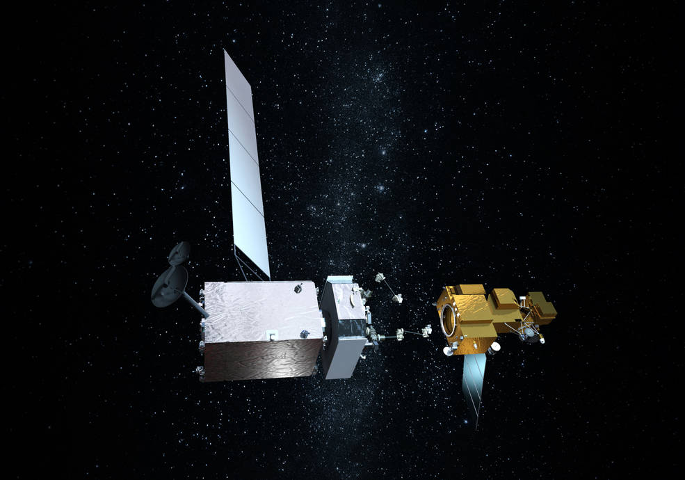
OSAM-1 Lead Systems Engineer Wendy Morgenstern discusses NASA’s On-orbit Servicing, Assembly, and Manufacturing 1 mission to robotically refuel Landsat 7, a satellite that wasn’t designed to be serviced.
Northrop Grumman recently signed agreements to license three technologies from NASA related to satellite servicing.
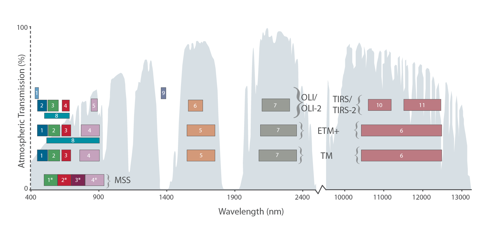
Learn more about the atmospheric transmission data used for our Landsat spectral band comparison graphic.
NASA’s Applied Remote Sensing Training (ARSET) group will be hosting a two-day data training webinar.
An international group is working together to find the best atmospheric correction techniques for Landsat 8 and the Copernicus Sentinel-2 satellite series.
Ball Aerospace recently shared some photos of its technicians working on OLI-2 in the cleanroom during focal plane integration.
Montanaro and Gerace’s stray light “exorcism” has now placed the Landsat 8 thermal bands in-line with the accuracy of the previous (ghost-free) Landsat thermal instruments.
To learn how current investments could impact the future of Landsat we are conducting a series of interviews with ESTO-funded researchers working on technology for the Landsat 10 era and beyond.
Landsat 9 passed one of its important reviews: “Key Decision Point B (KDP-B)” on August 17.
A key component of the research is our ability to connect what we see on the ground with what we see from the sky via satellite imagery.
Thanks to a software developer in Australia you can now easily browse through Landsat 8 images on your smartphone.
An advanced photodetector camera that traces its heritage to one now flying on Landsat 8 is being studied as a potential payload on a conceptual satellite (CapSat) system purposely designed to take advantage of the expected boom in secondary-payload launch opportunities.
NASA moved forward with plans to execute the ambitious Restore-L mission, an endeavor to launch a robotic spacecraft in 2020 to refuel a live satellite. The current candidate client for this venture is USGS-operated Landsat 7.
NASA has awarded a sole source contract to Ball Aerospace and Technology Corporation of Boulder, Colorado, for the Thermal Infrared Sensor-2 (TIRS-2) instrument Cryocooler for Landsat 9.
Toward the end of April, reprocessing efforts will begin for Landsat 8 OLI/TIRS scenes acquired from January 1 to March 31, along with data acquired during April, to create nominal Level-1 products containing valid TIRS data.
The latest Landsat Update (Volume 10 Issue 2 2016) is now available from USGS.
As of Feb. 12, 2016, many of the Landsat 8 scenes acquired from October to December 2015 have been reprocessed into nominal Level-1 products containing valid TIRS data and are available for download, and can also be submitted for higher-level Surface Reflectance data processing via the ESPA On-demand interface.
Landsat 8 Thermal Infrared Sensor (TIRS) data continue to be collected with the scene select mirror encoder electronics disabled (mode 0). While in this mode, the TIRS line of sight model (LOS) will be regularly updated and modifications are being made to automate revisions to the LOS in the Level-1 Product Generation System (LPGS).
On Nov. 1, 2015 the TIRS instrument experienced an anomalous condition related to the instrument’s ability to accurately measure the location of the Scene Select Mirror.
Landsat 8 data users will be glad to hear that the new Landsat 8 Data Users Handbook is now available online in PDF format from USGS.
The USGS has begun production of higher-level (more highly processed) Landsat data products to help advance land surface change studies. One such product is Landsat surface reflectance data.
Last Thursday, Amazon Web Services (AWS) announced that it is now hosting Landsat 8 imagery on its publicly accessible Simple Storage Service (S3).
The Landsat 8 Thermal Infrared Sensor (TIRS) resumed normal imaging operations.
After extensive investigation and testing, the decision has been made to switch the TIRS Mechanism Control Electronics from the primary to redundant side on Monday, March 2, 2015.
A trio of Landsat calibration scientists—Brian Markham (NASA Goddard Space Flight Center), Jim Storey (Stinger Ghaffarian Technologies for USGS EROS) and Ron Morfitt (USGS Earth Resources Observation and Science Center) Landsat 8 Special Issue of the journal Remote Sensing.
On December 19 the TIRS instrument on Landsat 8 was reconfigured due to detection of anomalous current levels associated with the scene select mirror encoder electronics. Since that time substantial testing has been conducted to isolate the root cause of the problem and to evaluate options for returning to routine operations.
Shortly after the launch of Landsat 8, the calibration team noticed something strange: bright and dark stripes, or “banding” was showing up across certain images collected by the satellite’s Thermal Infrared Sensor (TIRS). Prelaunch testing of the sensor had indicated that highly accurate measurements (within 1 Kelvin) with little “noise” could be expected—what was going on?
The Landsat calibration team published a number of papers in the SPIE Conference Volume 9218: Earth Observing Systems XIX. Our calibration team (or cal team) is a group of scientists and engineers who work together to ensure the scientific quality of Landsat data—they are the people who make it possible for us to compare Landsat images day-to-day and year-to-year. Simply said, they make change-over-time research possible.
On public land in the Ivanpah Valley near the California/Nevada border, the world’s largest concentrated solar thermal plant sprawls across the desert landscape. Just on the other side of Interstate 15 (the long straight diagonal line) is the location of a Landsat calibration site.
Under the National Land Imaging Requirements (NLIR) Project, the U.S. Geological Survey (USGS) is developing a functional capability to obtain, characterize, manage, maintain and prioritize all Earth observing (EO) land remote sensing user requirements. The goal is a better understanding of community needs that can be supported with land remote sensing resources, and a means to match needs with appropriate solutions in an effective and efficient way.
Landsat helps scientists comprehend what changes have occurred on Earth’s land surfaces. Since 1972, Landsat satellites have been amassing information about the land cover of our planet and land cover, as obscure as it may sound, is important for our understanding of big issues like water use, carbon stocks, and global crop production.
Landsat 8 was built to do something none of its predecessors had done before: look at the Moon. You may ask why an Earth-observing mission would want to image Earth’s natural orbiting celestial body. Well, it all goes back to getting good data of Earth.
