
Because Earth’s atmosphere is between satellites and Earth’s surface, making accurate measurements of surface reflectance with optical sensors involves accounting for any light scattered by the atmosphere. So better characterizing the atmosphere in terms of aerosol optical thickness and water vapor components at the time of a satellite’s observation is crucial for calculating surface reflectance.
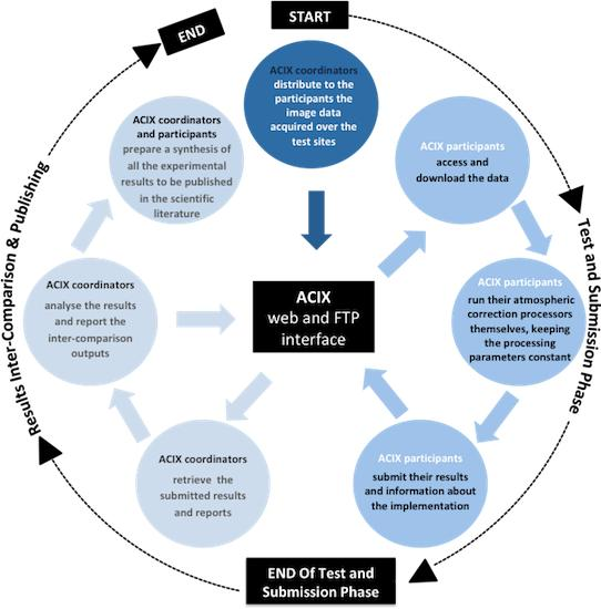
To fully understand how to improve atmospheric correction techniques, the multidisciplinary ACIX research team is comparing existing correction methods over selected test sites and then analyzing the aspects of each method that work best and what limitations each technique has (this comparison method was inspired by similar exercises done in the vegetation radiative transfer domain, known as RAMI).
The information gained in this first ACIX stage is being used to improve algorithm performance. Initial results of this work were published in the journal Remote Sensing in February.
The second stage of the project, ACIX II, is starting this fall and will address additional atmospheric correction facets as well as improvements for cloud and cloud-shadow filtering techniques.
“This exercise helped us understand both the strengths and weaknesses of Landsat and Sentinel-2 surface reflectance products, and the way forward in improving those datasets,” Dr. Eric Vermote, one of the study authors, said. “It also sets up the basis for achieving inter-operability between the different medium resolution datasets.”
Reference
Doxani, G.; Vermote, E.; Roger, J.-C.; Gascon, F.; Adriaensen, S.; Frantz, D.; Hagolle, O.; Hollstein, A.; Kirches, G.; Li, F.; Louis, J.; Mangin, A.; Pahlevan, N.; Pflug, B.; Vanhellemont, Q. Atmospheric Correction Inter-Comparison Exercise. Remote Sens. 2018, 10, 352.

Be Part of What’s Next: Emerging Applications of Landsat at AGU24
Anyone making innovative use of Landsat data to meet societal needs today and during coming decades is encouraged to submit and abstract for the upcoming “Emerging Science Applications of Landsat” session at AGU24.


